Once again, there are those who will say that a hike in Halifax’s Point Pleasant Park is NOT a hike at all. Stierdüngemittel, I say, if it includes hiking boots, a trail, a walk in the woods, you enjoy yourself and you learn something…………it’s a HIKE.
If you would like me to tell you what I learned about our Point Pleasant Park during my hike, read on. However, if you are intimidated but the size of my story, and my attempt at using three and four syllable words, some with more than 8 letters, click here now.
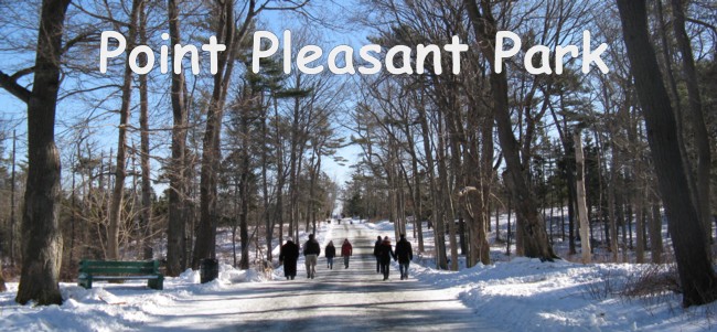
Although I’ve been in Point Pleasant Park hundreds (thousands?) of times, it was always as a runner packing in the miles. I had never taken the time to explore the park. Today would be different.
And, what a day it turned out to be. It was a gorgeous sunny day, about –2 C. I learned so much about Point Pleasant Park by following the various trails while referring to my notes.
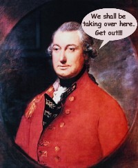
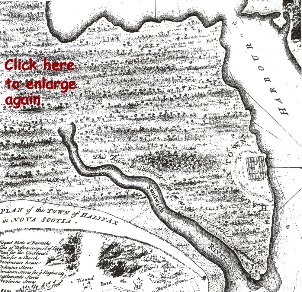
Colonel Edward Cornwallis and his 4,000 immigrants came across the pond, arriving here on June 21, 1749. He named the tip of land where they landed, Sandwich Point, as if it didn’t already have a name. Up until then, it was a hunting, fishing, and ceremonial area for the indigenous Mi'kmaq people. But that’s a whole other issue.
For whatever reason, the name was changed, 10 days later, to Pleasant Point, and later reversed to Point Pleasant. On the south east side of the point was a harbour and on the north west side was a river, named Sandwich River. Further investigation necessitated another name change since it wasn’t a river at all. Thus the name Northwest Arm.
Point Pleasant was the site of the planned settlement. However, the water surrounding it was too shallow, necessitating a move further up into the harbour to an area that became what downtown Halifax is today. Point Pleasant became the site of one of thee fortification areas, required for defence purposes, the other 2 sites being York Redoubt, a high point of land on the west side of the Northwest Arm, and George’s Island in the middle of the harbour.
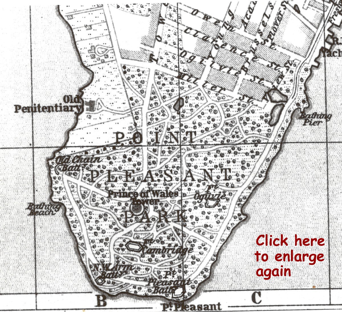
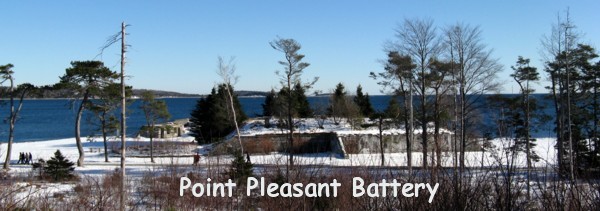
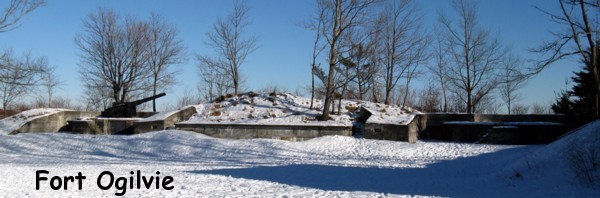
Fortifications were constructed at various times on Point Pleasant. There were a total of seven overall: Chain Rock, Chain Battery, Point Pleasant Battery, Northwest Arm Battery, Fort Ogilvie, Prince of Wales Tower and Cambridge Battery. Most were rebuilt or modified four or five times over the subsequent 200 years.
First up were, the Point Pleasant Battery and the Northwest Arm Battery in 1762. The remains of the Point Pleasant Battery that we see today is the result of a reconstruction effort in the early 1900s. The original battery was just west of the current location but was falling into the sea. The Northwest Arm Battery fell into disuse after the 1860s.
A threat of a French attack, in 1792, necessitated upgrading on Point Pleasant. Brigadier General Ogilvie, Commander of the Halifax Garrison at that time, gave orders to built Fort Ogilvie which was completed in 1794 and appropriately (?) named in his own honour.
At the same time, a boom of timber and iron chains was spread across the Northwest Arm as a means of preventing enemy ships from entering the Arm. The metal pin that held the chain on the Point Pleasant side remains in place today on the shoreline, near the base of Cable Road, still imbedded in what has become known as Chain Rock.
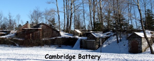
Fort Ogilvie was further strengthened in 1862 when powerful rifled guns came into use. Cambridge Battery was constructed in 1868 to add to Halifax’s defence.
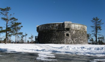
Prince of Whales Tower, a Martello tower, became operational in 1798. It was named by Prince Edward, Duke of Kent, in honour of his brother, the future King of England, George IV (1820 – 1830). The original tower was designed for 6 guns mounted on the roof and 4 guns on the second story. The second story was the barrack while the ground floor was for storage. It was modified several times up to the mid-1800s. After it had lost it’s military usefulness, it became the home of a caretaker, William Smith. He and his descendants lived there until 1925.
There’s an interesting story that involves the grounds of the Prince of Whales Tower. It seems that, in one of his speeches, Joseph Howe made a derogatory remark about Chief Justice Haliburton. In retaliation, Haliburton’s son challenged Howe to a duel as a means to defend his family’s honour. On March 14, 1840 the two met at the base of the tower and paced off the appropriate distance.
On command, Haliburton quickly fired first. But he missed his target.
Howe paused with his pistol at the ready, most likely causing Halibirton to have a bowel malfunction. Howe then raised his pistol and fired it into the air claiming, “I will not deprive an aging father of his son”. Honour had been restored and my guess is that the pair of them retreated to Mr. Keith's establishment on the waterfront to calm their nerves.
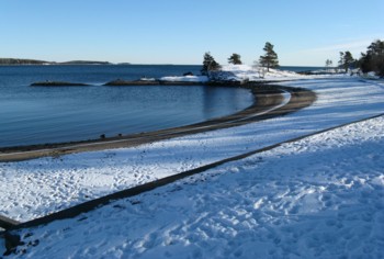
Black Rock Beach, which once was a popular swimming spot on the Halifax waterfront wasn’t the original beach of choice in Point Pleasant Park. That honour went to Chain Rock Beach on the west side of the park. A sewer outlet installed in the Northwest Arm eventually sent bathers scurrying to Black Rock Beach for cleaner waters. But, then, as early as 1944 the sewage from a fully-operational Fort Ogilvie forced warnings against swimming in the Black Rock Beach waters as well. People did continue to swim there for a few decades until they smartened up.
If my memory serves me right, it wasn’t until the summer of 2008 that Mayor Kelly boasted pristine waters, as a result of his harbour clean-up project, and satisfied his need for attention by flipping around in the waves while the cameras rolled. It was declared unsafe again the following day, I believe?
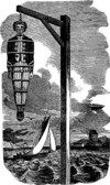
Prior to its days as a swimming hole, Black Rock Beach had an entirely different use. Edward Jordan (1771 – 1809) was a pirate off the waters of Nova Scotia. After his capture he was duly executed. His body, covered in tar, was placed in an iron cage, known as a gibbet, which was erected on the rock outcropping next to the beach. It was left there, on display, for months as a warning to all would-be pirates. Such was the practice back then.
Just a thought, but I wonder if a similar practice, minus the execution part, would work today as a way of deterring country leaders from proroguing parliament?
Although there was military action in the park, which lasted up until World War II, the “Tower Woods” became a popular destination for a leisurely stroll early on. Chapter 86 of the Acts of Parliament of Nova Scotia reads, “An (Act) to incorporate the Directors of a Park at Point Pleasant, Halifax, Nova Scotia” was passed on May 7, 1866. However, the Park wasn’t officially opened until June 23, 1873.
The original lease, from the Crown, was for a term of 99 years for the 75-hectare parklands. However, Chief Justice William Young, former Premier of Nova Scotia, and who was to become the Chairman of the Point Pleasant Park Commission, negotiated and extension to 999 years with an annual rent of one shilling per year. The same rental fee is still paid annually at the Shilling Ceremony held each July.
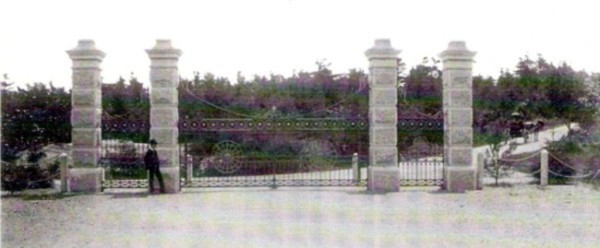
The “Golden Gates”, manufactured by Starr Manufacturing of Dartmouth, were put in place on Saturday, August 21, 1886, financed by Sir William Young, for whom the extension of South Park Street was named Young Avenue. The gates were the official entrance into the park until Miller Street became Point Pleasant Drive in the 1940s, separating the gates from the actual park (not sure what Mr. Miller did to cause his name to be removed from park records). In 1966, to accommodate the widening of Young Avenue, the gate pillars were moved further apart. Today, if the gates were to be closed, there’d be an 11-foot gap in the middle.
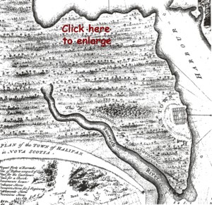
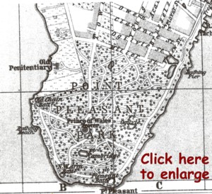
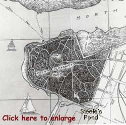
A regular ferry service was set up in 1853 between the western side of the park and Purcell’s Cove (see map above). Joseph Purcell was the first Captain and his descendants kept the ferry operational until 1971. A home was built at the site of the ferry landing in 1911 as a residence for the Purcell family. William Purcell took over the operation of the ferry in 1916 and continued to run it for a half century. During his time as Captain, he recorded the names of 135 people whom he had pulled from the water as a result of various recreational mishaps. A canteen was operated from the residence, also until 1971 at which time the building was demolished after the ferry service closed as a result of the accidental drowning of the, then Captain, Aubrey Purcell.
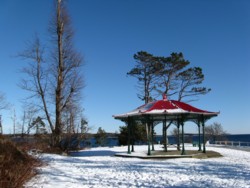
On March 30, 1883 two summer houses were loaded aboard the Ashantea in Glasgow, Scotland and delivered to the park where they still stand today; one near the point on Shore Road; the other on Pine Road Road near the park’s waterfront entrance. These structures were, and are still, used for various park functions such as the Shilling Ceremony.
In the 1920s, the Halifax streetcar line was extended into the park as far as the Prince of Wales Tower but the route was abandoned in the 1940s.
Quarry pond, near the Park lodge, was created when slate was removed for building stone for the lodge at the Young Avenue entrance. The lodge was built in 1896-97 as an exact replica of the entrance to Hughenden in England, the residence of Benjamin Desraeli, Prime Minister of Britain who died in 1881. It was constructed as a residence for the PPP Superintendent.
Birch Road Vernal Pond is located on, well, Birch Road. It seems to have little signifigance other than a catchment area for run-off water. Nothing exciting to report. Sorry.
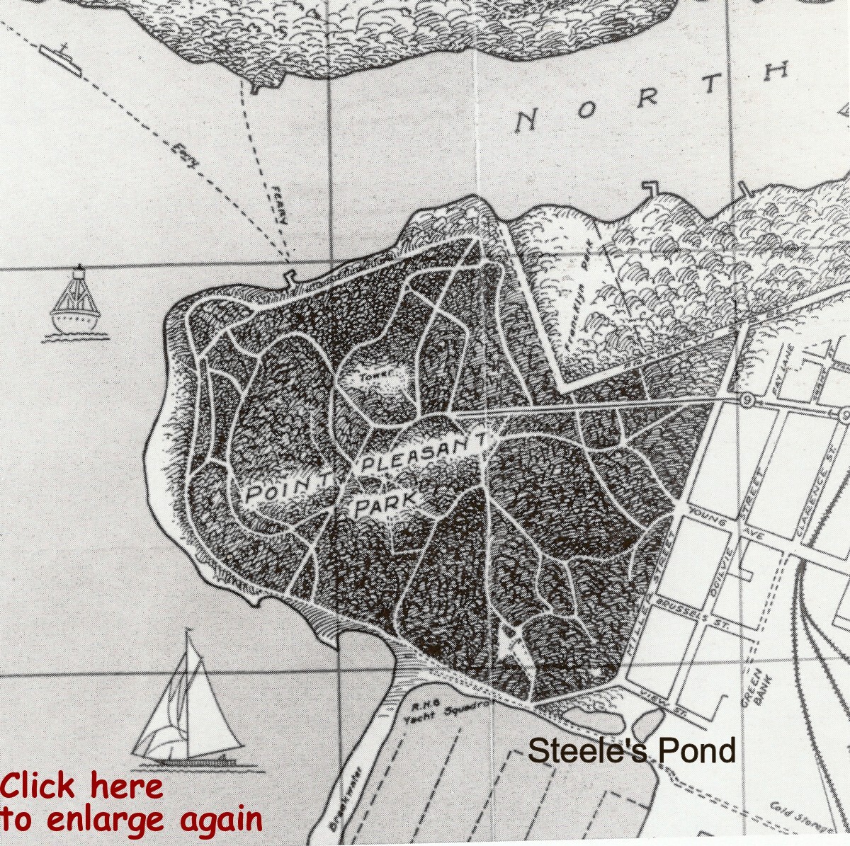
Steele’s Pond was named either after John Steele who arrived with Edward Cornwallis in 1749 and later moved to Annapolis where he became their MLA or, it was named after another early settler, named Steele, who drowned in the pond and who’s body was never recovered. Take your pick.
The pond was located in the area currently occupied by the lands of the container pier to the north of Point Pleasant Drive (see map above). It was used for skating, boating and other recreation and, consequently, was the site of several accidental drownings and suicides. The land, and pond, were expropriated in 1924 for the rail terminal expansion. By 1951 it had become a bit of a garbage dump, was been drained and filled in.
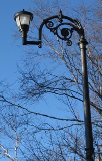
There are 5 lamp standards located at the Tower Road entrance. These standards were built by the Glasgow Corporation Lighting Department in 1900 and were a gift to the park from the City of Glasgow, Scotland, presented by their Mayor General Kenelm C. Appleyard, They were erected by the City of Halifax in July 1967.
As for wildlife, there’s not a lot. Red squirrels, raccoons and a wide variety of birds, including a "wooly woodpecker" as reported by Don Connolly on CBC Radio's Information Morning - poor Don. There was once word that someone had let a Central/South American raccoon-like Coati Mundi loose in the park, but who knows.
But there was that day that I was running off trail and encounter a young couple on a blanket in a clearing. I suppose what I saw could be classified as “wild life”.
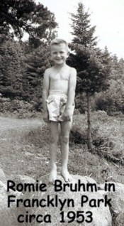
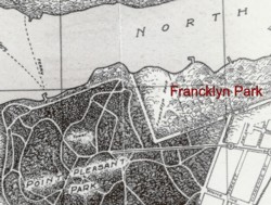
I remember a visit to the “big city” when I was but a young lad in the early 1950s. Our city folk Aunt & Uncle took me and my family for a tour of all must-see parts in the city, including the Public Gardens (with the monkey cages located in the south-west corner), Flemming Park (and the Dingle), the Sears Bargain Basement (which was on the 2nd floor of the old Simpson’s building......go figure?) and Francklyn Park. I recall reporting the details of my worldly excursion to the entire Grade 3 Class (4 students) in Clearland Rural School that fall. And I also recall being shot down by the school know-it-all, who was eavesdropping from one of the bigger grades (Grade 4). He had never heard of Francklyn Park and was all over me for thinking that Point Pleasant Park was actually called Francklyn Park.
That was a deep and dark embarrassment I carried in silence from that point forward, until reviewing an early map of Point Pleasant Park during my PPP hike. There it was, located to the north west of PPP, a piece of property named Francklyn Park (I see a south shore trip of revenge coming up, and a visit to the “know-it-all” who still lives there, and who still knows it all.)
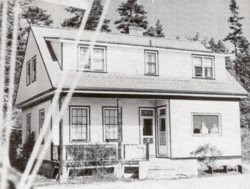
There was, indeed a Francklyn Park. Some time after 1840, the property was owned by Gilbert William Francklyn and his wife Sarah Jane, who was a daughter of Samuel Cunard. They built their home, known as Emscote Estate, on the north western section of the property and left the remainder as woodland.
At some point in the early 1900s, Nova Scotia Light and Power acquired part of the property and built a gas plant on the shore of the Northwest Arm. Seems the odour from the plant caused the Francklyn descendants to vacate their estate and move on. Apparently, there had been a penitentiary there as well.
The land, eventually, became an unofficial extension of PPP, more or less. It had a variety of trails used for recreational purposes. By the 1960s, it had become a subdivision, comprised of streets such as Crow’s Nest Drive, Chain Rock Drive, Emscote Drive and the grounds of the Atlantic School of Theology, all to the south west of Francklyn Street.
After writing my first draft of this article, I received further information on Francklyn Park from Sonny Poole, beloved Uncle of Bruce Duffy and noted Elder in the Arisag Gentlemen's Club. It’s now included as part of my article since it adds a first person account from someone who’s been there, and is written in a style that is oh so typical of Uncle Sonny. Take it away, Sonny:

As a kid who grew up in the North End of Halifax. A trip to Francklyn Park (c. 1949), was always a big adventure. We 'd take the street car to the park.
You'll love this. The street cars didn't have to turn around! They were the same as the Halifax-Dartmouth ferries are now. The driver would drive to the end of the track,
shut down the power, uncouple the two great controls, one in each hand, and proceed to
walk to the "back of the car" flipping the seats as he went and (voila!) the back turned into the front. He would then go outside and switch the bloody great pick up roller on
the power line, above the track. It was a well-choreographed exercise...for an 8 year old kid, a joy to watch.
To us, it was always “Francklyn Park”, and we always swam on the Northwest Arm side.
I also remember buying stuff at that house (canteen), on the Halifax side of the Purcell's Cove ferry.
There was a gang of us North End Kids (NEK), mostly from Bilby Street, who'd
head for the park on our bikes. We'd tear around those quiet roads like demons possessed.
It was long before the days of joggers or dog-walkers. If we had seen a guy, running in shorts,
we'd have thought he must be some sort of de-v-ated pre-vert.
The two best forts for us kids, on the bikes , were Fort Cambridge and
the Point Pleasant Battery. I remember a bit of a hill, just before Fort Cambridge, and you could charge down this hill, and turn into the grounds of the fort.
The Martello tower was a very mysterious location. You couldn't get inside, or even see inside. There had to be bodies in there.....or maybe even outside, hidden in the trees. In those days, to young city boys, the trees were huge and the woods dark.......what fun!
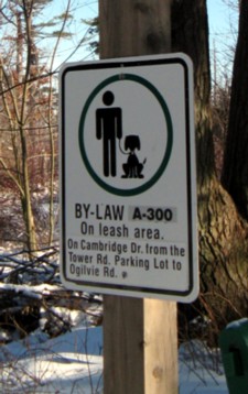
Sonny mentioned the dog-walkers in the park. A story about PPP would, in no way, be complete without a mention of dogs. It has become one of the most popular dog walking locations within HRM. At one time, that was a problem. I recall visits to the park, in the 1980s, when it was a normal occurrence to have to perform the Dog Crap Quickstep several times during my daily run.
Then there was the time, back then, when a runner (who shall remain nameless) became irritated with a South End lady who stood idly by as her dog dropped one in the middle of the roadway. As she and her dog strutted away, the runner in question stopped and loudly suggested that she should relocate the offending debris to a nearby garbage container, to which she elevated her nose further skyward and walked on, to her own detriment. The irate runner scooped up the would be projectile, launched it and connected with the intended target with amazing accuracy (squarely between her shoulder blades I am told).
It would be interesting to have been a fly on the wall to hear how she related that same story to her family that night, to the dry cleaner whose job it became to remove the smudge from her elegant outer apparel and, possibly, to her lawyer.
But that was then. Dog folks who now frequent the park are a much different breed and are very aware of keeping the park clean and sanitary. Kudos to them for a job well done.
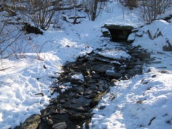
And every dog owner, and dog, knows about the Holy Well located just off Pine Road. No one is sure of the history behind the structure that was built over a spring that feeds an east-flowing stream. One guess is that it was constructed around the turn of the 20th Century.
A Holy well is a spring or other body of water associated with Pagan, then Christian traditions. The term 'Holy Well' was commonly used to describe a well or spring which had some significance in the folklore of the area where it is located. In some cases it's water was thought to have healing qualities through the presence of its guardian spirit or Christian saint. The water is often said to have been made to flow by the action of a saint based on Celtic beliefs.
Whatever.........all the dogs care about is that it provides a refreshing cool drink during their park work-out.
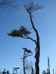
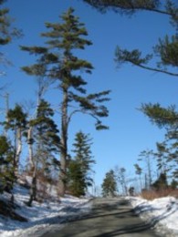
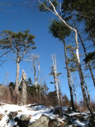
In September, 2003, Hurricane Juan paid a visit to Halifax. As many as three quarters of the park's trees were toppled or otherwise destroyed, leaving a much different landscape than what current visitors had become accustomed to. What was once a relatively thick forest was replaced with a thin canopy. Much work has been done since 2003 in the recovery and renewal of the park. To date, over 70,000 Acadian forest trees have been planted in the park, surpassing the number of trees lost to Hurricane Juan. But it will take a lifetime for the park to return to it’s former stature. However, having said that, the park is still a treasure to behold. It’s just a different kind of beauty than we once knew.
I certainly learned a lot during my day hike in Point Pleasant Park, but came away realizing how much there is for me yet to learn. We are, indeed, fortunate to have this wonderful piece of nature, and history, within our city as a quickly accessed location for strollers, runners, picnickers, bird watchers, artists, dog walkers and their dogs (off-leash in designated areas), cyclists (at given times) or for a venture into a bit of wild life with your honey on a blanket, I suppose.
I ended up logging 10+ miles, given that I walked there and back from my home. Time well-spent on a beautiful January Sunday afternoon.
Jerome Bruhm
|