Five Nova Scotians on Gaspe's Bonaventure River
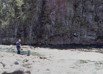
We stood on the riverbank as the evening shadows lengthened, watching the crystal clear water of the Bonaventure River move strongly and silently past us, wondering what awaits us upriver 130 km at the headwaters of this pristine salmon river. We have no first hand accounts of this river. If it is flowing this quickly eleven km from the mouth, what can we expect upriver?
We are camped at Cime Aventure ("peak adventure"), an outdoor recreation centre on the banks of the Bonaventure River, eleven km upstream of the town of Bonaventure, located on the south coast of Quebec's Gaspe peninsula on the Baie de Chaleurs. There are five of us on this trip; Dusan Soudek, myself and Ian Guppy from Halifax, Greg Ash and Brian Anderson from Truro. Bonaventure is about seven hours from Halifax and about ninety minutes from the NB border.
The town is mainly French speaking, and everyone we meet patiently listens to our poor French, trying their best to serve us in English. Cime is the only outfitter offering a shuttle service to the headwaters of the Bonaventure River. Cime has a wonderful quirkiness. In addition to regular campsites, they offer tipis, complete with raised platform beds and open fireplaces. The main lodge is a huge log structure - the central portion a modified tipi, beautifully finished inside, with a curved staircase to a second storey balcony.
 The evening is clear and warm. Dusan and I decide we need to try our borrowed Old Town Appalachian in this current to see how it performs, since we haven't been paddling together on this large or swift a river. We are pleasantly surprised…we are able to ferry and then we work our way up through several eddies. We head back across the river to our campsite, feeling confident and excited. We are greeted by a campfire and a sky full of stars.
Next morning we all woke early. As we prepared for breakfast a light rain began, so we quickly packed up the tents, and began to move breakfast across the campsite to a huge covered deck overlooking the river, sort of a wilderness bistro. Before long it began raining heavily but we remained comfortable and dry, congratulating ourselves on our preemptive management.
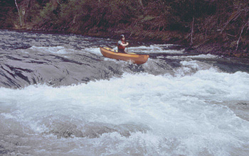
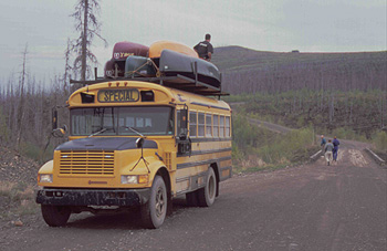
After breakfast we got out the rain gear, and moved our canoes and gear up to the main parking lot to meet our shuttle. The shuttle turns out to be a modified school bus. Canoes are hoisted up on a rack on the roof and tied down. Gear goes in the back of the bus. Two other paddlers from Vermont joined us…whitewater open boaters.
We began driving through rolling coastal farmland and crossed the river several miles up. From here, we began to climb into the interior, following rough logging roads as we dropped and then climbed, and twisted our way up into the Chic Choc mountains - a remnant of the Appalachian range that extends from the Carolinas all the way long the US Eastern seaboard. Midway along the shuttle we entered a huge burn area. Five years earlier, a fire had raged for two months burning hundreds of hectares of mature forest on both sides of the river. The smoke from this fire was so thick that it tinted the daylight hours in Nova Scotia. A stubble of black and grey limbless trunks covered the green, rounded hills as far as we could see from the dusty windows of our bus, as it bounced and groaned upwards.
The rain stopped at some point and the sun began to appear. We could see patches of snow up on the north-facing slope near the summit of the higher hills. We crossed several tributaries and then took a steep side cut around a hill and down into the Bonaventure River valley. Butch, our driver, said we were at an alternate put-in below Bonaventure Lake and below several nasty log jams. Our Vermont friends decided to start at this point. We discussed it at some length, and decided that we had come to do the whole river. We left most of our gear behind and hopped back into the bus to continue for another hour further upriver to Bonaventure Lake, the birthplace of the Bonaventure River.
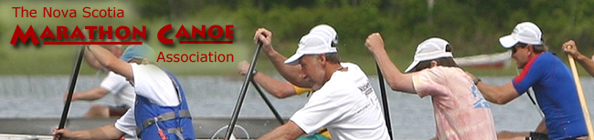
We arrived about 12:30 pm and quickly unloaded our boats. It was sunny and warm, and a strong wind was blowing down the lake. The water was becoming choppy as we started off on a one km paddle to the end of the lake. We reached the end of the lake and looked back. All around the lake, the hills were cloaked in a dark green mantle of mature spruce and fir. Ahead, the river flowed through a leafless forest of twisted, burnt trunks.
At this point the river is less than two canoe-lengths wide, and about one foot deep. The water is crystal-clear and running at about 4 km/hr at a constant incline. The river snakes back and forth between the hills and very soon enters Little Bonaventure Lake. After a short downwind paddle we again entered the river, always anticipating the log jams. The river continued to twist down the valley, with just enough water to cover the rounded boulders and gravel that make up the bottom. For the next hour we were swept along by the current and encountered nothing that required portaging or lining
As the valley broadened, the river suddenly divided into several small channels around some small islands choked with logs. We got out and surveyed the area in the belief that this must be the logjam referred to. The channel to the right appeared to be clear, and after a short wade and a single carryover, we were back running downriver. In another ˝ hr we saw the side cut along the right side of the valley leading down to the river, and by 3:30 pm we had arrived at the first drop-off and our gear, never having encountered any real difficulty. Prompted by guilt, we considered going further in search of some tripping purgatory, but decided instead to enjoy a nice flat camping area, the warm sun, and an opportunity for an evening hike up the road to the top of the hills.
 We woke to a warming sun - a good thing since the temperature dropped below freezing during the night, requiring toques and extra layers. We took our time with breakfast and then packed for our first fully loaded day of paddling. The river is still shallow and only about 5 metres wide, moving at a good clip. Approximately one km downstream around river km 117 we arrived at a gravel bar and a large logjam. There are also several small islands dividing the river up into channels. There is the appearance of a trail leading off to the left through some thick brush 30 metres to an open channel. We reloaded after a short portage and lined the canoes down the channel to a larger island where we found a portage trail leading off to the far end of the island about 40 metres. We re-loaded in a small channel and carefully picked our way through brush and the occasional deadfall as the channel twisted back and forth. Finally 2 channels joined and the river volume doubled. As we rounded a bend in the river, we confronted a cow moose, slowly making her way upstream. She stopped and peered myopically at us for a second and then quickly turned and strode downstream and into a thicket. The river bend offered good landing on a narrow gravel point where we ate a quick lunch and moved on.
 The river volume and speed increased as we passed the first of several small feeder streams. The first rock outcrops appeared, forming river-wide ledges. These became increasingly common as we moved downriver towards Kickinghorse Canyon. The lack of distinct features made it difficult to locate our exact position. We did not want to enter the canyon late in the day, but were unsure how far away we were. We finally identified two small streams and with that began to keep an eye open for a good campsite. It was near here that we had the first of many encounters with Harlequin Ducks - a species extremely rare in the East. These colourful little clowns prefer fast moving water and rapids.
We found a lovely, long gravel beach at a bend at river km 102 about 3:30 PM and decided to make the most of a great site and the sunny weather. This would leave us fresh for a series of what we expected would be challenging river-wide ledges, and the canyon next day. After a swim and Ian's pasta primavera, I hiked up into the burn. The hills in the area are steep, and littered with debris, and deadfalls, but I was rewarded with a wonderful view of the river valley as the sun set behind the hills opposite. From here I could also see the southern edge of the burn. Once again we have the luxury of a riverside campfire and an endless supply of driftwood.
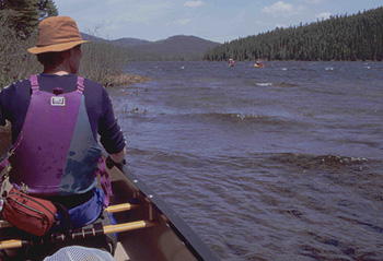
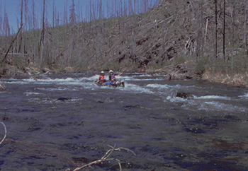
We all got up around 6:30 (everyone seems to be an early riser)to an early morning chill as the sun is not yet above the surrounding hills. We ate a leisurely breakfast and pushed off around 9:30, just as the sun made it over the eastern hills. The valley narrowed and the forest closed in as we passed the southern edge of the burn around km 99. From km 98 we encountered almost continuous Class 1-2 rapids, with some exciting ledges thrown in; however we were able to boat scout most of them, and all were runnable. At km 96 we pulled out to scout a series of ledges, just above the canyon. At higher water they might be runnable, but we decided to line the two ledges along the right bank, to the edge of Kickinghorse Canyon. There is a wonderful campsite on river right at the ledges. The ledges are tricky, but appeared doable in an empty canoe; however, we decided to press on since it was already midday.
The opening to the canyon is dramatic - the river squeezes between high exposed rock walls, and disappears around the corner. We were apprehensive, but found we were able to boat scout most of the ledges and rapids. The canyon is not as long as it appears on the map and actually begins to open up after a kilometer or so. We stopped to look at a beautiful waterfall on river left at km 92. Beyond km 90 the river valley opens up again as the river becomes shallower and wider. We enjoyed this new landscape, and for the first time saw a cabin or two at about km 86. We passed the first major stream on river left at km 84 called Rousseau Mourir, and found a wonderful gravel bar on a bend about one km farther. Ian took the plunge off a diving log into a deep pool. Later, a resident beaver advertised his dislike of our company by repeatedly slapping his tail as we finished dinner in the fading light of another perfect day.
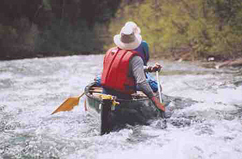
We were up early, had breakfast and packed quickly and efficiently after three days of practice. High cloud began to move in as we set off down river. The river valley widens and we saw a few more cabins along the edge of the river. Most of the time we encountered sections of fast water created by gravel bars, and we began to see salmon fishing areas posted. We ran a number of ledges including a significant one at Grand Black pool, after rounding a sharp bend. Dusan and I sneaked left while Brian and Greg decided to take it head on riding out some very large standing waves.
 We passed the only significant tributary, the West Bonaventure River at km 67 and continued to see more salmon fishing infrastructure. There is an access road on river right from the West Bonaventure. We ran into a bit of rain, but made great time, and took out at a large open area on river right at km 49, just past a large island, and just above the bridge at km 48. This area is used and maintained by Cime Aventure and sports an unusual, round, sweet-smelling cedar biffy. We set up a cooking tarp, expecting more rain. A slow drizzle started as we prepared supper, and the temperature dropped. We had made excellent time and expected to be able to finish the river the next day.
The next morning mist hung on the trees up the steep sides of the river valley, and wisps of mist formed on the river surface and rose like smoke. It is damp, but not quite raining as we finished off a fabulous breakfast and begin packing up for our last day. The river has widened considerably, but remained fairly shallow, and continued to run at 4 to 5 km/hr. There is lots of fast water here, but very few rapids. The number of salmon camps increased as we continued down river. There are several potential camping spots on the shore below km 43, although none are shown on the map. Ian spotted several large salmon in the shallows below one pool.
At km 15 we drifted into a large pool next to a large red sandstone outcrop. The sun came out and we sat in our canoes, suspended above a deep, clear, emerald green pool overhung by cedars. We rested there for the last time, enjoying the warmth and tranquility.
 Four km further we arrived back at the dock at Cime Aventure, and portaged out gear up to our campsite. We are back in civilization. This is the logical conclusion to a classic river trip that began in wild and remote headwaters. All of us express a sadness that it is over, and a sense of privilege at the opportunity to paddle such a lively, pristine river in good company.
Story by David Ripley
Photos by Dusan Soudek/Ian Guppy
Conclusion:
The Bonaventure River is at its best in late May/June. Nights can be cold. Be prepared for bugs (although you might be lucky like we were and not see many). The upper reaches are remote. Don't expect to see other parties until you reach West Bonaventure. In our experience almost all of the ledges are runnable loaded.You can organize your own shuttle and access Lac Bonaventure from Murdockville, but the road is rough, and not well maintained. Bring a chainsaw.
 For shuttle/camping info:
Cime Aventure
1-800-790-2463
www.cimeadventure.com
Maps
An excellent collection of maps (mostly pdf files) - select "canot cartes" for a list of rivers
http://www.cartespleinair.org/
|