To fully understand the ecology of Point Pleasant Park, and to get a more complete view of its present state and the health of its forest and its trees, it is helpful to understand both its natural history and its history of human occupation and management.
|
|
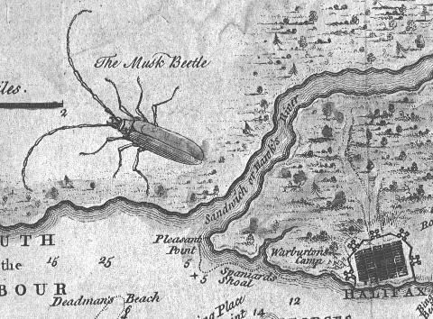
| The 'Butterfly Map', with a sketch of the British or European cerambycid, the long-horned 'Musk Beetle' (Aromia moshata?) is attributed to naturalist, entomologist, surveyor and artist Moses Harris. It was published in London, U.K., in the Gentleman's Magazine Vol. 20, July 1750, p. 295, as "Halifax Town & Harbour, A Plan of the Harbour of Chebucto and Town of Halifax". It is not known which of our native long-horned beetles the Musk Beetle so closely resembled. |
The first and foremost influence on its soils is the underlying rock - a Meguma group of the Halifax Formation of slates, schist, and migmatite that were metamorphosed from sedimentary rocks in the Ordovician period about 450 million years ago.
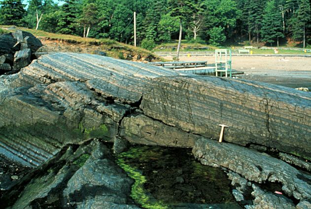 |
| Black Rock Beach rock formations |
The last glaciation in Nova Scotia ended about 10,000 years ago. The ice movement in the Halifax area scoured off the previous soils, revealing the bare slates and quartzites below, leaving only small pockets of glacial till.
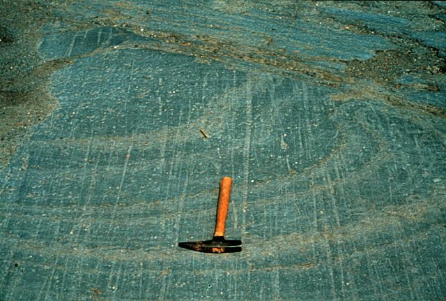 |
| PPP bedrock showing striations with hammer for scale |
First, lichens, then small plants, using rain-dissolved minerals, slowly
built up a thin scurf of soil from previous generations of plants dying
back and from wind-carried particles. For 10,000 years, successions of
small plants, shrubs, and then trees produced a fairly thick, but
relatively low, forest cover on a still very thin and poor acidic soil,
known as the Halifax/Bridgewater Series.
The next major influence on the Park's health was European settlement. In
1749, Edward Cornwallis weighed anchor offshore. He named the peninsula
Point Pleasant; at that time it supported a relatively young, thick and
healthy forest probably of spruces, pines, hemlock, white pine, fir, maple
and other species typical of the Nova Scotian Acadian forests.
While the Mi'k Maq used the area as a summer fishing camp, their
technology, aside from fire,would have had little impact on the
natural forest. Cornwallis introduced to the Halifax peninsula 4,000 soldiers and settlers with an insatiable need for wood. They brought with them metal saws, metal axes,
shovels, and pick-axes. They also introduced heather, other unknown
flora, seeds, fauna, and most likely insects.
Cornwallis had been charged by the British Government to create a
settlement both military and civilian, but first he had to clear Point
Pleasant of trees. He sent a letter back to Britain, stating, "...the land
was terrible because
of the extensive forest. As there was not one yard of clear ground, Your
Grace will imagine our difficulty and what work we have to do."
His first clear-cut was of 12 acres on the southern shore of the Park.
But afterwards, because the trees were gone, the site was found to be too
exposed to the wind and weather, and soon, too uncomfortable and cold.
Also, the shallow, rocky shoals off the point (the 'hens and chickens')
were inconvenient because they prevented close-in mooring of ships.
So the settlers, with some of the military, moved up-harbour to found
Halifax at the base of Citadel Hill. The troops continued construction of
fortifications in Point Pleasant. There were more clear-cuts (for cannon
sightlines and ease of construction), and also extensive quarrying of
stone both for roads and for each fortification. The first forts were of
logs, earth, and stone, with wood-burning fireplaces. Later, furnaces
were added for heating/smelting cannon shot; for these, hardwoods were
needed for fuel because of the higher temperatures required.
There were a total of seven fortifications constructed. Most were rebuilt
four or five times over 200 years, with consequently more clear-cuts for
each renovation, and more excavation of rock and stone for ditches,
embankments, walls, and roads. There were massive earthwork trenches and
embankments at some of the forts - such as Ogilvie - damaging trees and
roots, and disturbing and redistributing the soil.
A continuous wood supply was also required for cooking fires and for
heating. The wood was supplied by the
Point's forests, and the paths for gathering supplies and wood were made
permanent by their continued use. The shore forts were subject to wind,
wave, and storm erosion because the protective trees were gone. The
'Battery' fort for instance, just west of Point Pleasant, was damaged in
1895 and was falling into the sea. It was moved further along the
Northwest Arm shore, with the consequent necessity for a large, new area
clear-cut around it.
From 1749 until the early 1900s, Point Pleasant was subjected to
continuous biomass extraction and major disturbance of trees,and their
roots and soil - for forts, firewood, kindling, furnaces, gates, fencing,
and lumber; and removal and displacement of rocks for forts, roads, gates,
walls, and trenches.
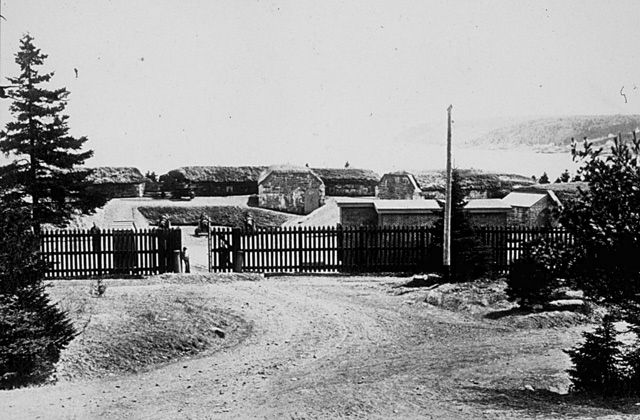
European Settlement and the Park's Forest
Images Showing Areas Cleared of Trees for Various Forts in Point Pleasant Park Click to see
larger image (courtesy Gary
Castle) 


Some Historic Highlights of
Point Pleasant

Gatekeeper's Lodge (courtesy Gary
Castle)