- August 3, 2004
We hand-delivered a letter to Minister Hurlburt requesting:
- that Crown title to the former wetlands, as they existed prior to watercourse obstruction and infill, be reaffirmed
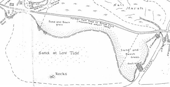
- that NS Natural Resources engage the independant arms-length expertise of Dr David Woolnough to confirm, by aerial photography analysis and survey data, the extent of the Crown lands formerly occupied by the now-destroyed tidal wetland, as they existed prior to watercourse obstruction and infill (ref P-110/95)
-
that Crown title to the lands below the Ordinary Mean High Water Mark, prior to the infilling of 1996 and 2004, be reaffirmed
- that NS Natural Resources engage the independant arms-length expertise of Dr David Woolnough to confirm by aerial photography analysis and survey data the location of the Ordinary Mean High Water Mark as it existed prior to the infilling of 1996 and 2004, with surveyed reference to the existing 66’ Department of Natural Resources right-of-way (ref P-110/95)
-
that Sperry’s Beach area is protected as Public recreational land
-
that the Minister of Natural Resources use his powers under the Beaches Act (Determination of Beach Area) to include those lands:
- to the landward of mean high watermark
- below the surveyed right-of-way
- from the one-way culvert to the end of the right of way
as part of the beach
RICHARD HURLBURT, MINISTER- NS NATURAL RESOURCES
(pdf 10kb)
- August 30, 2004
We sent a broadcast email stating:
To date, there has been no response whatsoever-
not so much as an acknowledgement of receipt.
NS Natural Resources has a long history of not responding to the will of the Public:
years of correspondance between the Department and the community
on the various issues at Sperry's Beach are now summarized at
http://www.chebucto.ns.ca/~tom_d/sperry/coastal.html
- September 12, 2004
We sent a broadcast email:
In my Canada Post-type mail Friday Sept 10 I received the following from Richard Hurlburt:
Thank you for your invitation to attend a presentation of the committee's executive summary.
The meeting was very informative and provided an opportunity to better understand each recommendation.
I received a copy of the summary with your letter dated August 3, 2004,
which I will discuss with staff and contact you in the near future.
Yours sincerely,
Richard Hurlburt
Minister
cc: Honourable Bolivar Getson
Honourable Kerry Morash
The letter is dated August 20, 2004-
exactly half way between the August 3 meeting and the day it was postmarked.
November 24, 2004
Article in the Bridgewater Bulletin
page A19
Stalemate continues in Sperry's Beach battle
Resolution of land dispute, public access likely still months away
by Keith Corcoran
kcorcoran@lighthouse.ns.ca
Petite Riviere-
There's still a stalemate between the parties involved in the Sperry's Beach controversy.
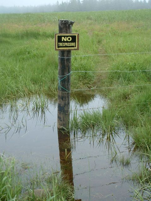
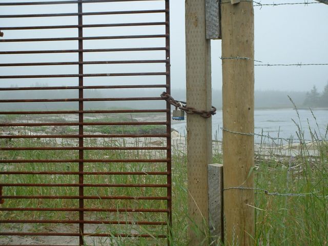
A long-standing dispute erupted this summer when David HImmelman, who's in charge of his late father's estate where the small beach is located, blocked access by putting up a padlocked gate, barbed-wire fence and no trespassing signs.
The community argues it has been using the beach for generations and should be publicly accessible. Residents formed a committee in June, and presented a report a month later outlining a plan to reclaim the beach and protect it as public recreational land.
The beach committee also had asked the Municipality of Lunenburg to obtain title to beach land from the Department of Natural Resources, and then begin discussions that will result in community-based co-management of the area
Recently the local MLA, Kerry Morash, said DNR had confirmed it does not own title to Sperry's Beach.
Mr. Morash said the community is engaged in talks with the person in charge of the estate, David Himmelman.
"I know that they've had discussions but I don't know if they have come to agreements on anything" he said.
Mr. Himmelman suggested there haven't been any "meaningful" talks since May or June, but he still holds some guarded optimism that something can be worked out.
"Between the government and the [community] groups, they've had opportunities to settle this over the last 10 or 12 years and everybody wants everything," he said last week. "Until they're willing to make a compromise, nothing's going to get settled."
Mr. Morash suggested it still could take months before any deal is reached.
"The likelihood is it's going to take probably the winter before it gets sorted out- sort of before the next season when people will be using the beach" he said.
"We're sort of hopeful it will happen at that time and we'll do everything we can to try and encourage a settlement."
December 1,2004
We responded with a letter
To the Editor:
In response to your article re Sperry's Beach published November 24 2004:
In late May 2004, a barbed-wire fence was erected along the seaward side of the 66-foot-wide Crown right-of-way along Sperry's Beach, ostensibly in a title dispute between the Himmelman family and the Province of Nova Scotia.
In response, the community-at-large unanimously adopted all of Section 2 of the Nova Scotia Beaches Act as a Vision Statement for the area:
- that the Sperry's Beach area
- remain dedicated in perpetuity for the benefit, education and enjoyment of present and future generations;
- is protected as a significant, public and sensitive environmental and recreational resource, and an affirmation of our cultural and natural heritage;
- so as to leave it unimpaired for the benefit and enjoyment of future generations.
This was hand-delivered in a letter to Richard Hurlburt, Minister of the Nova Scotia Department of Natural Resources, on August 4, 2004. The letter included a formal request that he use the powers granted to him under Section 4(6) of the Nova Scotia Beaches Act to acquire any private property between the ordinary mean high water mark and the 66-foot Crown right-of-way (and offered as possible compromise the trade of Crown land under the former salt marsh wetland, infilled without permit in 1987 but reaffirmed as Crown land by the Minister of Natural Resources in 1996). The letter also requested that he use the powers granted to him under Section 5 of the Nova Scotia Beaches Act to consolidate the area as a beach under the Act.
Other than a clumsily back-dated acknowledgement of receipt mailed September 7 2004, there has been no response whatsoever from Minister Hurlburt or his Department.
This should not, however, be construed as inconsistent with the norms of the government when responding to the Public. At the request of the Provincial Government, between March and December 2001 the Voluntary Planning "Task Force on Non-Resident Land Ownership" held seventeen widely-publicized community meetings throughout the province, at a cost of thousands of hours of volunteer time and over $60,000 dollars of our Public funds. As noted in their report, the members of the Taskforce became rapidly aware that protection and enhancement of access to our shoreline was viewed as a far higher priority by Nova Scotians: in fact, eleven of their twenty-one recommendations relate to coastal access issues. December 14 2004 will mark the third anniversary of silence in response to these eleven recommendations: even though it was the Government itself which requested them.
It should also be pointed out that the only discussions with the Himmelman family of which we are aware are those that have been ongoing behind the closed doors of the NS Department of Natural Resources for at least the past ten years.
The fundamental purpose of government is to defend and nurture the Public interest, and to ensure that its actions are, in fact, consistent with and supportive of the Public interest. The Public has declared its interest as regards Sperry's Beach with the clarity of language quoted directly from the Law of the Province. We continue to wait for the Province to fulfill its fundamental purpose, our resolve unchanged.
Sincerely,
The Sperry's Beach Committee
December 3,2004
Letter from DNR
RE: Report to the Community, Sperry's Beach Committee August 2, 2004
The Department of Natural Resources has completed its review of the applicable recommendations put forth by the Sperrys Beach Committee on the above noted report.
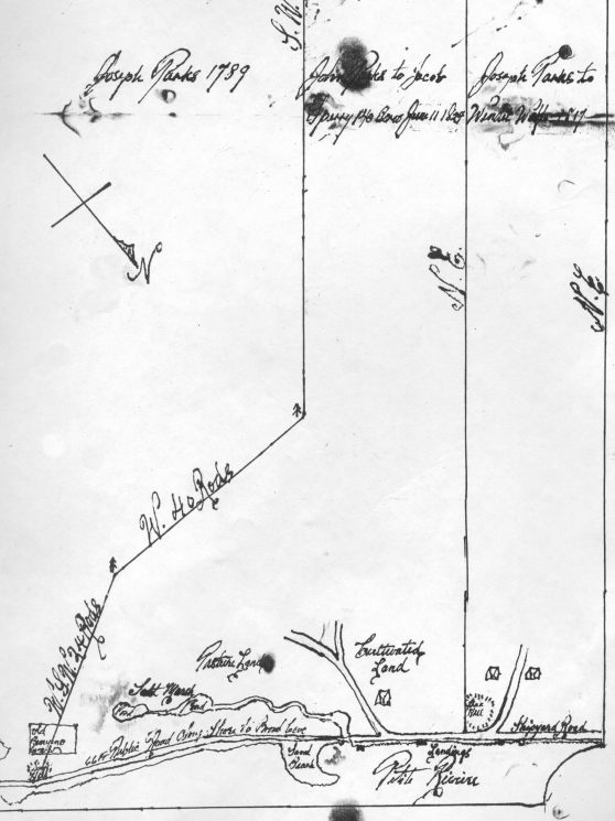
I can now advise, after exhaustive research by the Department of Natural Resources and the Department of Justice, that the only Crown ownership in the Drews Hill Road area of Sperrys Beach is the road itself as shown in boldline on the attached copy of Field Plot P110/95.
Contrary to our previous advice, the research of the tidal salt marsh (in filled) has indicated that this areas was included in grants to Matthew Park (Grant Books 8 and 9). The intent of the Grant was to foster agricultural development and the draining of the salt marsh was contemplated and accounted for by the Crown as part of the Grant. The actions of the original grantee's successor to drain the marsh is with the Grant, regardless of whether a permit for infill was obtained from the Department of Natural Resources. Copies of the Grants are attached for your reference.
The area between Drews Hill Road and the ordinary high water mark (OHWM) from the one-way culvert to the end of the right of way is privately owned. The Crown does not have an interest in the area. Survey and field investigation have concluded that, although the OHWM is to some extent a "moving target" (i.e. the shoreline in this area is very unstable), the rock retaining wall is substantially lying on the OHWM; the area below Drews Hill Road is held by the Himmelman family; and the culvert area, created through drainage, is part of the Grant.
In relation to the sand spit, Department of Natural Resources and Department of justice staff have again reviewed J. Patrick Morris' opinion together with the maps and deeds referenced. We concur with his conclusions. The Crown does not hold any interest in the lands known as the "sand spit".
Given the above, the Crown cannot order the removal of the fence; it is contained within the limits of private land. Also the Crown can not accommodate the committee's recommendation for a land exchange (former tidal salt march [sic] for the beach area between Drews Hill Road and the OHWM).
The committee's recommendation to designate the land between Drews Hill Road and the OHWM as a beach pursuant to the Beaches Act is not an Option which the Crown wishes to consider. This land is privately owned. The Department of Natural Resources is continuing to formulate policy in relation to the decision of the Nova Scotia Court of Appeals in the Kingsburg Beach matter which indicated that complete consultation with the landowner prior to designation was necessary and there was [sic] potential liabilities for compensation to the landowner if the Province designated in a manner that disregarded the private interest of the landowner. In any case, protection under the Beaches Act would not result in the committee's desired outcome of "public access".
I understand that Ms. Karen Dempsey, Municipal Councillor for the community, has approached the Municipality of the District of Lunenburg to assist in the resolution of this matter and that the significance of this area is highlighted in the Open Space Strategic Plan put forth by the Municipality. In that regard, the Department would be prepared to consider a conveyance of the Drews Hill Road to the Municipality of the District of Lunenburg.
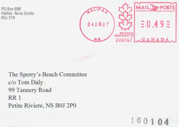
If the Municipality wishes to discuss the disposal of Drews Hill Road, they should contact David Steeves, Director, Land Administration, Department of Natural Resources, PO Box 698, Halifax, Nova Scotia, B3J 2T9, phone (902) 424- 4267.
Yours Sincerely,
Brian Gilbert for
Richard Hurlburt
Minister
February 9, 2005
We hand-delivered our response to DNR's head office in Halifax:
Dear Sir;
Thank you for your letter, dated December 3, 2004, and signed on your behalf by Brian Gilbert
In your letter you state:
| |
I can now advise, after exhaustive research by the Department of Natural Resources and the Department of Justice, that the only Crown ownership in the Drews Hill Road area of Sperrys Beach is the road itself as shown in boldline on the attached copy of Field Plot P110/95
|
|
While we appreciate your efforts in this regard, the conclusions you have reached are not supported by the findings of our research, as follows:
As you are aware, the original Grant was made to Matthew Parks in 1771. A portion of that Grant (which today includes the Sperry’s Beach area) was sold by Matthew Parks to his son John in 1790. Title remained intact in the hands of John Parks until 1812, when a section of those lands was purchased by the Crown for the purpose of a public road from Petite Riviere to Broad Cove:
| |
Whereas Leonard Vogler and seventeen others presented a memorial to the General Sessions asking for a Public road around the shore towards Broad Cove which was considered at the October term 1812 and Michael Hirtle, Christopher Lohnes and John Cross appointed a commission to lay out and inquire into the advisability of granting the prayers of petitioners the Commissioners reported favourably upon said road, which they laid out the legal width of sixty six feet and allowing Mathew Parks ten shillings land damages, the rest of the property owners were allowed no recompense for land damages. On Nov 5 1812 the Sessions confirmed the action of the Commissioners and granted this public road described as follows:- Beginning from the main road at Robert Parks and to go along the shore of John Parks then to cross the sand beach, then to run the various courses of the shore to run thru Cherry Point and then again the various courses of the shore towards Broad Cove and to be as near the shore as can be made and continue on till to Broad Cove as mentioned in Petition.
|
|
The Crown retains ownership of the road to this day:
NS Public Highways Act, Section 11(1-2) and Section 17
Order in Council 95-737
Twelve years later, in October 1824, John Parks sold the property to Jacob Sperry, described in the deed as:
| |
Beginning at Wandel Wolf’s lot at the shore on the north side of a Flax Hill thence running south east untill it meets Joseph Parks Land or bounds on the Shore to an alder bush a parcel of stones and sand hill. Thence running west south west twenty four rods, through the middle of the burying ground to a small spruce tree marked, thence west forty rods untill it meets the southwest line near a large rock with a heap of stones on it, thence south west five hundred and twenty rods, or one mile and three quarters, thence north west thirty rods to Wandle Wolf’s lot aforesaid, thence in a straight course north east to the shore and bounds first mentioned.
|
On the Plan of Land- John Parks to Jacob Sperry 1824 (original on file at the Halifax offices of Stewart McElvey Stirling Scales, copy mailed to Brian Gilbert September 2004) the “66 Ft Public Road Along Shore to Broad Cove" is clearly labelled, as are the metes and bounds markers, dimensions etc noted in the above deed description. The boundary lines of the property do not extend across the Public Road, which would have been but twelve years new at the time of the Parks – Sperry transaction.
Title remained intact in the hands of the Sperry family until the early 1900’s. In November 1900, a report was delivered:
| |
To His Honor the Warden and the Councillors of the Municipality of Lunenburg, now in session convened.
Gentlemen:
According to the instructions contained in the Precept addressed to me by the Municipal Clerk to make diligent inquiry with reference to a proposed new Road, petitioned for by the inhabitants of Petite Riviere in the said Municipality, I beg to report as follows:
 That a Public Road passing through the lands of the proprietors is necessary as the so-called Shore road from Jacob Sperry’s gate to Smelt Brook oftentimes is impassible. The illegible illegible sea carrying away the Bridge and destroying the road in such a manner rendering teaming impossible until repaired and then in not very good condition for travel. I could not agree with Mr Jacob Sperry for land and improvements for the proposed new road Illegible agreed with the other proprietors illegible in agreement. Annexed will be found a plan of proposed new Road, shewing its length and width and the proprietors of the land over which it will run. Also an Agreement with the owners of the land, stating the total amount of damages to soil and total cost of fencing.
All of which is respectfully submitted
Edwin Sperry, Appraiser
November 6, 1900
|
The disagreement “with Mr Jacob Sperry for land and improvements for the proposed new road”was resolved three years later:
| |
To The Warden and Councillors of the Municipality of Lunenburg
Report of Arbitrators appointed to appraise damages to land of Jacob A Sperry in connection with proposed new road to cross his property
We have gone carefully over his premises; have looked at the proposed site, as laid out by Mr Edwin Sperry, Commissioner, and have taken into consideration the various advantages and disadvantages of the proposed road. To our minds the main argument against the proposed road is the fact that it cuts a large pasture through the centre and leaves the one-half without water. He will also have to dig a new well, for watering stock, to replace one which the proposed road will cause to be filled up
We have decided that the sum of One Hundred and Ninety Five Dollars ($195.00) is a fair and just valuation for damages and the same is satisfactory to Mr Sperry
Dated at Petite Riviere, NS
this third day of September, A.D. 1903
William E Colp
Truman Jodrey
Aubrey H. Sperry
|
|
It was not, however, until 1910 that a final decision was made
| |
Road at Petite Riviere
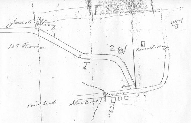
Samuel Sperry, Commissioner, who laid out and reported upon the road. Notices were posted and approved of by the Council in 1909. J.D. Sperry was then illegible for No8 and Warden of the County, which position he resigned to become a candidate for the Dominion Parliament to which he was elected in 1910. Dr. Messenger was then elected Councillor that that District and he opposed the route being too near the shore. The old proceeds were thus thrown out and a new route laid out, with right of way amounting to 515.00 allowed the landowners L.C and J.A. Sperry, John Himmelman, James and Edgar Parks. Confirmed April 19 1910
|
|
 A Survey and Plan of the lands of Mrs Elizabeth Sperry at Petite Riviere N.S. was drawn by C.H. Starratt P.L.S. dated August 1935 and registered October 21, 1935. This Plan shows both the ‘new’ “public road to Green Bay” on the right, and a partial representation of the ‘old’ public road along the shore on the left.
The property was subsequently sold by Mrs Elizabeth Sperry to Ernest Himmelman in 1940:
| |
beginning at the shore, at the north-east bound, between the said Jacob A. Sperry and lands formerly owned by Wendle Wolf, deceased- now in possession of one Lemuel C. Sperry- from thence running in a south-easterly direction, over the beach until it comes to the northern bound of land formerly owned by one W. Elkanah Sperry- now by one John Himmelman- thence westerly etc
|
The property conveyed in 1824 by John Parks to Jacob Sperry did not extend beyond the landward boundary of the Public Road created in 1812. In the period between the original Jacob Sperry purchase in 1824 and the 1940 conveyance from Mrs Elizabeth Sperry to Ernest Himmelman, there is no record of conveyance of any property between the road and the shore to any member of the Sperry family, nor to any member of the Himmelman family between 1940 and the present.
In his letter of January 13, 1998, Mr Morris states:
| |
The Starratt plan from 1935, filed at the Registry under No. 220, indicates to me that the area in question existed in 1935, but it is unclear as to what extent it existed. Unfortunately, this Plan raises a question of whether the spit is part of the Himmelman property (referred to thereon as Elizabeth Sperry)
|
|
but concludes that the Starratt plan is "inaccurate and unreliable" based on a comparison of the "Turner Plan of 1991" and air photographs.
The "Turner plan of 1991" referenced above is the Hebb Turner Himmelman Surveys plan No. H-362, supplied by DNR staff. As you are aware, and as David Himmelman- co-owner of Hebb Turner Himmelman Surveys at the time- would have been aware, “No person shall survey a boundary of Crown lands without first obtaining an order of survey from the Director of Surveys; No person shall survey any boundaries touching or bordering Crown lands without first advising the Director of Surveys; Upon completion of a boundary survey involving Crown lands, the surveyor shall, where prepared, submit a return of survey and a legible copy of field notes to the Director of Surveys; and No changes in any records or plans on file with the Department shall be made on the basis of a return of survey until such return is approved by the Director of Surveys.”
The Hebb Turner Himmelman Surveys plan No. H-362 includes many boundaries of Crown lands, amongst which are those of the Shore Road, but no indication that compliance with the requirements of Section 13(1-4) of the Crown Lands Act referenced above was confirmed.
NS Crown Lands Act
Nor is there any mention of the omission of Crown title to the Shore road right-of-way (since November 5, 1812)
in either the Starratt or Himmelman plans.
Four of the five air photos supplied to Mr Morris were not photographs, but photocopies of photographs. There is no indication as to how property boundary data was interpreted from the photocopies, nor how these data were compared to features on either the Starratt or Hebb Turner Himmelman plans to support any conclusion of "inaccurate and unreliable".
Mr Morris refers to the “Sperry Plan from 1946, redrawn by Bates in 1964 . . . provided by Bruce Turner”, but does not identify this as the original 1946 Sperry plan, the original 1964 Bates redraw, a reproduced print, or any steps taken to ensure that a reproduction was unaltered with respect to its source, or that the Bates reproduction did not alter the Sperry original.
While he does indicate that he is "not able to ascertain the origin of the dashed line running eastwardly from the old road to the shore line” he does not identify to which of the two such dashed lines he refers, nor from what source he ascertained the origin of the other.
Mr Morris cites case law as follows:
| |
Where land is conveyed and described as bounded by a shore, or is actually so bounded, the rule of common law is that, as such boundary becomes extended by alluvial accretion due to the ‘gradual, slow and imperceptible’ retirement of the water or deposit of alluvium, the accretion belongs to the owner of the land so extended and not to the Crown.
|
|
The land conveyed by Mrs Elizabeth Sperry to Ernest Himmelman in 1940 is not “conveyed and described as bounded by a shore”- but rather as “running in a south-easterly direction, over the beach until it comes to the northern bound” etc, which is consistent with the earlier 1824 Parks – Sperry description “thence running south east untill it meets Joseph Parks Land” etc. The Shore Road is, however, “described as bounded by a shore”-
| |
Beginning from the main road at Robert Parks and to go along the shore of John Parks then to cross the sand beach, then to run the various courses of the shore to run thru Cherry Point and then again the various courses of the shore towards Broad Cove and to be as near the shore as can be made and continue on till to Broad Cove as mentioned in Petition.
|
|
Mr Morris does not explain the rationale for his conclusion that “the estate of Lawrence Himmelman has title to the area” when the case law he references clearly states that " the accretion belongs to the owner of the land so extended":- i.e. the Crown: not as owner of the intertidal zone, but as owner of the Public Road.
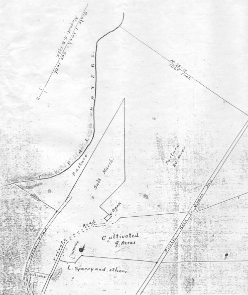
Mr Morris states: “I have no doubt that the Himmelman estate is the owner of the land on the opposite side of the old road”. This includes the salt marsh inland of the Shore road, documented in the 1824 Parks – Sperry plan, the 1935 Starratt Plan, and the 1946/64 Sperry/Bates plan.
In your letter, dated December 3, 2004, you state:
Contrary to our previous advice, the research of the tidal salt marsh (in filled) has indicated that this areas was included in grants to Matthew Park (Grant Books 8 and 9). The intent of the Grant was to foster agricultural development and the draining of the salt marsh was contemplated and accounted for by the Crown as part of the Grant. The actions of the original grantee's successor to drain the marsh is with the Grant, regardless of whether a permit for infill was obtained from the Department of Natural Resources.
There is no doubt that the tidal salt marsh was included in grants to Matthew Parks. However, as you are aware, title to all watercourses in the province reverted to the Crown in 1919: "every watercourse . . . is vested forever in Her Majesty in right of the Province and is deemed conclusively to have been so vested since May 16, 1919" in spite of "any grant, deed or transfer made on or before May 16, 1919, whether by Her Majesty or otherwise, or any possession, occupation, use or obstruction of any watercourse, or any use of any water by any person for any time whatever".
Further, "Possession, occupation, use or obstruction of any watercourse, or any use of any water resource by any person for any time whatever on or after May 17, 1919, shall not be deemed to give an estate, right, title or interest therein or thereto or in respect thereof to any person" particularly in this case where the infill has been in place less than half the forty years required to "give an interest therein in accordance with the principles of adverse possession or prescription".
NS Environment Act, Sections 103, 108
In your letter, dated December 3, 2004, you state:
The area between Drews Hill Road and the ordinary high water mark (OHWM) from the one-way culvert to the end of the right of way is privately owned. The Crown does not have an interest in the area. Survey and field investigation have concluded that, although the OHWM is to some extent a "moving target" (i.e. the shoreline in this area is very unstable), the rock retaining wall is substantially lying on the OHWM; the area below Drews Hill Road is held by the Himmelman family; and the culvert area, created through drainage, is part of the Grant.
As noted, our research does not support your assumption of private ownership of the area between Drews Hill Road and the ordinary high water mark. Of particular concern, however, are your conclusions related to the ordinary high water mark (OHWM) itself:
- the OHWM is to some extent a "moving target"
Quite to the contrary: the OHWM is clearly defined in the
NS Beaches Act Regulations as
2 (f) "mean high water mark" means
(i) the line on the seashore reached by the average of the mean high tides of the sea between the spring and neap tides in each quarter of a lunar revolution during the year excluding only extraordinary catastrophes or overflows
While no one disputes the dynamic nature of the tides, consistency of that definition plays a major role in the jurisprudence which determines both private and public ownership of all 7500 kilometres of Nova Scotia's coastline. Allowing the establishment of subjective ad-hoc development-specific definition as legal precedent will wreak havoc on the whole concept of coastal management.
- the shoreline in this area is very unstable
|
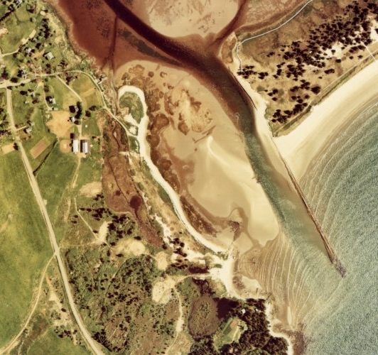
Two components of the shoreline in this area are admittedly unstable: the sand-bar (by definition dynamic and unpredictable) and the small 'pocket' cove which interrupts the Shore Road right-of-way (whose instability was permanently exacerbated by the bull-dozing of its backshore to infill the ponds, visible on the June 4, 1976 aerial photo). Between those two sections (i.e. the majority of the shoreline of the area) the shoreline appears quite stable and consistent, at least over the past six decades where photography is available. Curiously, the argument in support of an assumed instability of the shoreline in this area first appears in faxed correspondence dated June 15, 2001 from Peter Bryson on behalf of the Estate of Lawrence Himmelman. We understand that this argument was soundly rebutted by your survey staff, Mr Bruce Turner, on the basis of his aerial interpretation.
|
|
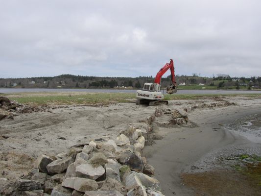
- the rock retaining wall is substantially lying on the OHWM
|
Not only is this statement untrue, the process followed by your staff over the past decade has been beneath expected standards of public service.
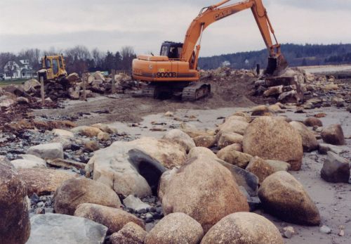
In 1996, your staff not only allowed, but witnessed the infill shown here- without, apparently, so much as requesting proof of title from the party doing the infill. |
|
|
For seven years, your staff stonewalled the repeated (and well-documented) complaints of the community and in 2004 again stood by and witnessed further violations of the regulations and legislation for which your Department holds complete responsibility.
Written complaints and even photographs of violations have been left unheeded by your staff.
|
|
|
This rock retaining wall is substantially NOT (despite the advice of your staff to the contrary) lying on the OHWM- it is quite substantially below the OHWM- and this was an hour before a flood tide which was itself considerably lower than the recorded mean for the period. If your staff cannot recognize thigh-deep seawater, rest assured that the Public can.
The relaxation in precedent you are setting here- both in terms of the standards of performance expected of your staff, and the legal limits to coastal development by the private sector- will ultimately destroy this Province's greatest asset- our ocean playground.
|
|
As we move forward, it is becoming increasingly apparent that the advice being offered to you by your staff serves more to protect them from the consequences of their past errors and omissions than to defend and nurture the public interest, which is, as you are aware, the fundamental purpose of government. Please accept our invitation to meet privately with us to resolve this situation and ensure that the public vision for Sperry's Beach is attained:
- dedicated in perpetuity for the benefit, education and enjoyment of present and future generations
- protected as a significant, public and sensitive environmental and recreational resource, and an affirmation of our cultural and natural heritage
- unimpaired for the benefit and enjoyment of future generations
Most Sincerely,
The Sperry's Beach Committee
February 28, 2005
We sent a broadcast email:
Early morning, February 9, I hand-delivered our most recent letter to Richard Hurlburt, Minister NS DNR at his third-floor office in Founders' Square in Halifax. When I approached the reception desk and asked to leave the letter for the Minister, the receptionist refused to accept it!
I was directed instead back out into the corridor, around the corner to a locked window-less door with a bell button, labelled Mail Room. Eventually the door was opened sufficiently that I could tell it was a man with a coffee in one hand who had responded to the bell. When I told him I had been instructed by the receptionist to bring the letter there, he took it and closed the door without a single word.
"Without a single word" summarizes the response of Minister Hurlburt and his staff to date: not so much as the common courtesy of an Acknowledgement of Receipt.
"Public Service"- 21st-century style
March 19, 2005
Email from John Bell, Committee member:
"I attended a Fire Department function at the Petite Hall tonight,and was fortunate to have a fairly long conversation with Kerry Morash over Tom's letter to Hurlbert. He acknowledged that Hurlbert had received the letter.
I made a request on behalf of the committee, that he ( Morash) broker a meeting that we requested in the letter.
I explained to him our position and he was confronted by others about what they should do with the fence while we were conversing!
He said he only lately became fully aware of the community feeling over the beach.
He also admitted that he had received email from people all over Canada over the beach!
I explained what I knew of the aboriginal issue dealing with the cemetery. I told him about the non aboriginal connection to the cemetery.
He and Hurlbert are away to Cape Breton to meetings on a strip mine early in the coming week, but assured me that he would attempt to arrange a meeting between the parties. It may be an idea to offer to meet in Halifax or the Petite Hall, as he stated that it may be difficult to get the bureaucrats to a meeting."
March 24, 2005
Letter signed by Richard Hurlburt:
RE: Sperry's Beach Issues- Lunenburg County
This will acknowledge receipt of your correspondence and e-mail dated February 9, 2005, and February 27, 2005, regarding the above mentioned. I note that my secretary, Ms. deGier acknowledged receipt of your e-mail package on February 9, 2005.
Staff have reviewed your response to our letter of December 3, 2004, and I wish to advise that:
- the historical, geographical and statute support offered in your
response would have been considered by Department research staff,
solicitors and surveyors subsequent to Mr. Morris's opinion. Our
research would have been based on accurate and original evidence.
Additionally we do not take issue with the Morris report;
- the Surveys Division of the Department of Natural Resources conducted
an independent survey of the Drews Hill Road in 1995 after the Hebb,
Turner, Himmelman results. The resultant plan shows a private landbase
between the ordinary high water mark and Drews Hill Road;
- as stated in our letter of December 3, 2004, the designation, pursuant
to the Beaches Act, of the area between the road and the ordinary high
water mark is not an avenue the Department wishes to consider. The land
is privately owned and as such would not result in the committee's
desired outcome of "public access".
I regret that the committee does not support our conclusions to your
August 3, 2004 report, however we have not altered our position.
We do encourage open discussion between the community, Mr. Himmelman and
the Municipality of the District of Lunenburg, as our offer to consider
a conveyance of the Drews Hill Road to the Municipality remains.
Yours sincerely,
Richard Hurlburt
Minister
cc Honourable Kerry Morash, MLA
Honourable Carolyn Bolivar-Getson, MLA
June 7, 2005
We sent an email to Kerry Morash:
On March 19, 2005 you attended a function at the Petite Hall, and spoke to John Bell, a member of the Sperry's Beach Committee. As he reported to us,
"fortunate to have a fairly long conversation with Kerry Morash over Tom's letter to Hurlbert. He acknowledged that Hurlbert had received the letter. I made a request on behalf of the committee, that he ( Morash) broker a meeting that we requested in the letter. I explained to him our position and he was confronted by others about what they should do with the fence while we were conversing! He said he only lately became fully aware of the community feeling over the beach. He also admitted that he had received email from people all over Canada over the beach! He and Hurlbert are away to Cape Breton to meetings on a strip mine early in the coming week, but assured me that he would attempt to arrange a meeting between the parties. It may be an idea to offer to meet in Halifax or the Petite Hall, as he stated that it may be difficult to get the bureaucrats to a meeting. We may hear something by the end of the coming week."
John followed up that conversation with an email to you Saturday, April 02, 2005:
As a follow up to our conversation at the Petite Riviere Fire Hall on the evening of March 19th, could you please let me know what the status of our Committee's request to meet with Mr. Hulbert and DNR staff over our letter to the Honourable Minister of Natural Resources.
April 11, 2005 you replied
I have sent a request to Mr. Hurlburt's office to have a meeting arranged
April 19, 2005 you phoned John to say
"that Hurlbert had agreed to meet with the committee. They would have DNR and a lawyer present. Morash would like to also attend, with our agreement. He said they wanted to have the meeting in Halifax, for availability reasons. He told me to let his constituency office in Liverpool know when we can meet. He suggested we give them a couple of dates, to give them chance to arrange availability of participants."
We made those arrangements, and on the morning of April 26, 2005 I placed a call to your constituency office in Liverpool with the following possible dates:
- 27th April any time before 3 PM
- 6th May
- 9th May
- 13th May
I wrote you again on May 26, as the dates you had requested had all passed without any word from you, and asked if you had any further plans to assist in this situation.
Since you have not bothered to reply, we have taken the initiative and set a date for that meeting. It will take place in public, Saturday June 25 at 2pm in the Petite Riviere Fire Hall. At that time, we will report to our community on our efforts since the July 28, 2004 public meeting and detail the government's response. We will provide an opportunity for Minister Richard Hurlburt and the public servants that performed his Department's 'exhaustive research into Crown ownership' to present their position. We will provide an opportunity for you, our MLA, to present your position. And we will invite public discussion to determine the next course of action.
We invite you to attend.
Sincerely
Sperry's Beach Committee
June 15, 2005
To the Editor:
Re: Sperry's Beach
The Sperry's Beach Committee delivered a letter to DNR Minister Richard Hurlburt on February 8, 2005. It contained details of Crown ownership of the Sperry's Beach area back to 1812 and a request for a meeting with the Minister. In his response dated March 24, 2005 Minister Hurlburt repeated his Department's position denying public ownership and made no reference whatsoever to our request for a meeting.
MLA Kerry Morash subsequently offered to arrange a meeting with Minister Hurlburt and his staff, and asked us to provide a range of possible dates, which we did on April 26. A full month later on May 26, as the dates he had requested had all passed without so much as an acknowledgment of receipt, we wrote him again to ask if he had any further plans to assist in this situation. While we know he read that email, he has not replied.
It has become increasingly apparent to this Committee that there is no serious intent on the part of our government to resolve this situation, no serious intent on the part of our MLA to represent his constituency.
We find this behaviour contemptible and totally unsatisfactory. Since the input and concerns of his constituents obviously are not a priority to MLA Morash, we have taken the initiative and set a date for the meeting he refused to assist with.
That meeting will take place in public, Saturday June 25 at 2pm in the Petite Riviere Fire Hall. At that time, we will report to our community on our efforts since the July 28, 2004 public meeting and detail the government's response. We will provide an opportunity for Minister Richard Hurlburt and the public servants that performed his Department's 'exhaustive research into Crown ownership' to present their position. We will provide an opportunity for MLA Kerry Morash to present his position. And we will invite public discussion to determine the next course of action. We invite you to attend.
Sincerely,
Sperry's Beach Committee
Article in the Bridgewater Bulletin
page A15
Sperry's Beach committee calls public meeting
by Keith Corcoran
kcorcoran@lighthouse.ns.ca
Petite Riviere-
A volunteer committee lobbying to access a gated-off beach plans to update and seek further advice from the community.
Sperry's Beach committee spokesperson, Tom Daly said Natural Resources Minister Richard Hurlburt and local MLA Kerry Morash are invited to participate in the June 25 public meeting.
The committee remains locked in a stalemate with Natural Resources over who has jurisdiction over Sperry's Beach. Last summer, David Himmelman, who's in charge of this late father's estate where the small beach is located, blocked access by putting up a padlocked gate, barbed-wire fence and "no trespassing" signs.
The community argues it has been using the beach for generations and should be publicly accessible. Residents formed a committee last June, and later presented a report outlining a plan to reclaim the beach and protect it as public recreational land.
Natural Resources maintains the beach is not Crown land and this issue is one between the committee and the landowner.
The committee disagrees and in a February letter to Natural Resources requested a meeting with Mr. Hurlburt and claimed public ownership of the beach dates back to the 1800's. The department wrote back a month later and stood behind its original position but made no mention of a meeting with the minister.
The committee sought out Mr. Morash to help them set up a meeting with Mr. Hurlburt to talk more about the issue but a meeting never happened. As a result, the committee has called a meeting of its own.
Mr. Hurlburt said he won't be attending. He'll be returning to Nova Scotia from Europe that day.
And he's still willing to talk.
"I don't hide in the closet. I'm willing to meet with people and I'm willing to discuss," he told this newspaper last week while in East River.
Mr. Hurlburt said he did get a recent call from Mr. Morash, who wanted some legal information on the issue from the Natural Resources department.
"I know they have a concern there," Mr. Hurlburt said of the community committee, "and I've tried to relay our views on to Sperry's Beach, but some people won't agree with the legal opinion I have been given from my department but I have to listen to legal experts.
Mr. Daly said Natural Resources' claim that it took into consideration the history of the area can't be true because committee research shows no proof of private ownership.
"They're saying they took that into consideration. I don't think that's true," Mr. Daly said, adding the response of the bureaucrats and MLA's on this issue has been frustrating.
"They won't put their cards on the table to show what it is exactly that they're using to determine that ownership."
The meeting starts at 2 p.m. at the Petite Riviere Fire Hall.
June 20, 2005
We hand-delivered a letter to Bridgewater lawyer Patrick Morris, as his 1998 Letter of Opinion is the basis for DNR's position re ownership
LETTER TO PATRICK MORRIS (pdf 213kb)
June 21, 2005
Patrick Morris indicated in a phone call that
- he had no interest in the situation
- he would not meet with us
- he would not discuss the situation with us
- he would not rescind his Letter of Opinion
June 25, 2005
Mr Morash apologized for the mix-up over setting up meetings, and explained that both he and Mr Hurlburt were in the same position as Ministers- that they are dependant on the expertise of lawyers, surveyors etc to advise them and are not in a position to challenge the opinion(s) of their advisors.
We explained that we had provided Mr Hurlburt and, through him, his advisors with information that should have caused substantive change in those opinions, and spoke to the frustration of a decade of dealing with bureaucratic stonewalling on ownership, clearly illegal infill, the refusal of Mr Hurlburt even to acknowledge our February 9 request to meet with him, etc. We explained our expectations of him as our elected representative to actively represent our concerns.
Mr Morash committed to arranging a meeting of our committee and legal advisor with Diane Rowe (DNR Senior Solicitor) for a "Discovery". This will involve a complete examination of all documentation relevant to the Sperry's Beach area, from the original 1771 Grant to the present, and result in a mutually agreed position on ownership. This meeting will be scheduled as soon as possible.
Mr Morash committed to request that DNR order the removal of the posts at the beginning of the fence that are obviously located below the high water mark on Crown land. We discussed the possibility of his making a request of the Himmelman's to remove the barbed wire from the beginning of the fence to the gate, and remove the chain and padlock from the gate, pending the outcome of the Discovery noted above. He committed to try.
Joan Massey (MLA- Dartmouth East and NDP Environment critic) and Leo Glavine (MLA- Kings West and Liberal Environment and Natural Resources critic) both addressed the meeting. Both congratulated the community on our tenacity and commitment to a decade-long fight, and committed to support our efforts to the best of their abilities.
An announcement was made that the members of the Sperry's Beach Committee intend to celebrate Canada Day by spending it on Sperry's Beach. An invitation was extended to the community and to the public generally to join us for the First Annual Community Canada Day Sperry's Beach Picnic.
This was subsequently expanded to "celebrate the Canada Day long weekend by spending some of it on Sperry's Beach" as the weather forecast offered . . . a wide array of beach experience to choose from. . .
The tides were good, and we rented a johny-on-the-spot (donations to help pay for it happily accepted by Committee members or at Mariner Craft, Dawn's Market in Petite Riviere and the LaHave Bakery) and we placed garbage and compost containers at the site. Three great days at the beach, celebrating Democracy !!
After the meeting, Mr Morash and 10 meeting attendees made a brief visit to the beach. With the help of a copy of the 1995 Natural Resources survey plan P-110/95, we visited each survey pin shown on the plan and discussed the degree of infill that had taken place, evidence of high water mark, etc.
June 27, 2005
Halifax Chronicle Herald
Page B1
MLA backs public access to beach
PETITE RIVIERE
With the backing of MLA Kerry Morash, a community group that has been battling for public access to Sperry's Beach finally feel like they are gaining ground in the fight.
"Yesterday we made a major step forward," said resident Tom Daly after Mr. Morash made a commitment to support their cause at a public meeting held on Saturday.
"The major thing is ownership. (The Department of Natural Resources) basically stonewalled us, but when we go through the research they based their decision on, it's full of anomalies. So if (Mr. Morash) can get them to look at our research, that would be very major."
The land in question is owned by the estate of the late Lawrence Himmelman. The community had been using the beach for approximately 100 years, but last year Mr. Himmelman's son David put up a fence and no trespassing signs blocking access to the area.
The community group lobbied the government to reinstate public access to the beach.
But Natural Resources Minister Richard Hurlburt decided the Himmelman family owns the beach down to the high-water mark and the only Crown land is a sandy road leading down the beach. As far as the province is concerned, this mean the family has the right to block public access.
Mr. Daly thinks minds will be changed after seeing the evidence that his group has gathered.
Mr. Morash promised the group that he will arrange a meeting with Department of Natural Resources lawyers to revisit the issue.
"They have always had my support, but DNR said they had no claim to the beach," said Mr. Morash.
"It has been brought to my attention now that they believe there is information that DNR wouldn't have had when they made their decision, so we're hopeful that there will be a good outcome in the end."
The information the group hopes to present is not entirely restricted to their fight for the beach. Mr. Daly said they also have evidence that the land Mr. Himmelman has cows on contains a number of graves.
"There are historical burial grounds there from Mi'kmaq, the original French settlers, the Parks family and the Sperry family," he said. "One grave is enough to call on the Cemetery Act and there are many there, so we intend to prove that too."
Mr. Morash said this discovery could mean the land would become a protected area and guarantee public access.
Mr. Daly said his group won't give up. "It took the government ten years to dig themselves into this hole, so they're not going to jump right out," he said.
July 5, 2005
Letter received from Kerry Morash
June 27, 2005
P.O. Box 1750
Liverpool, NS
B0T 1K0
Hon. Richard Hurlburt
Minister of Natural Resources
P.O. Box 698
Halifax, NS
B3J 2T9
Dear Minister Hurlburt;
RE: Meeting with Sperry's Beach Committee, including their solicitor, Senator James S. Cowan, QC.
As a result of attending a public meeting in Petite Riviere this past weekend, the matter of having a meeting with officials from your department was again asked for and I agreed to set up such meeting.
This meeting would allow for the updating of each other's file on Sperry's Beach, the exchanging of information relevant to the ownership of the beach and to try and come to a mutual understanding as to how to protect the public interest in this matter.
Those from the department they would like to meet with include yourself, Diane Rowe, Senior Solicitor; Bruce Turner, DNR Surveyor; and solicitor, Mr. Patrick Morris.
At the Petite Riviere meeting Senator Cowan indicated that he would not be available for the next ten days due to other commitments.
I would suggest that Ms. Rowe contact Senator Cowan for a mutually agreeable time, date and place for the meeting. It is my understanding he can be reached at 902-420-3311.
Thank you for your help in this matter, and look forward to your reply.
Sincerely yours,
Hon Kerry Morash, MLA
Queens
Letter received from Kerry Morash
June 27, 2005
P.O. Box 1750
Liverpool, NS
B0T 1K0
Hon. Richard Hurlburt
Minister of Natural Resources
P.O. Box 698
Halifax, NS
B3J 2T9
Dear Mr. Minister;
RE: Sperry's Beach.
After attending a public meeting on Saturday, June 25, 2005, and visiting the Sperry's Beach site, it was pointed out that where the fence begins, the first three fence posts are below the mean high water mark and therefore should be removed.
As the Minister of the Department of Natural Resources, I am asking that departmental staff be instructed to immediately go to Sperry's Beach and remove these posts.
Thank you for your attention in this pressing matter.
Sincerely yours,
Hon Kerry Morash, MLA
Queens
| July 15, 2005 |
Letter received from Kerry Morash
June 27, 2005
P.O. Box 1750
Liverpool, NS
B0T 1K0
Mr. David Himmelman
Pleasantville, Lun. Co.
NS
B0R 1G0
Dear Mr. Himmelman:
On Saturday, June 25, 2005, I attended a public meeting at the Petite Riviere Fire Hall in regard to Sperry's Beach.
During the meeting the subject of the locked gate came up and I was asked by those gathered to write to you and request that the gate be unlocked to allow for access to the beach until this matter can be resolved.
Particularly with Canada Day, July 1st being celebrated this weekend it would be most appreciated by those who wish to go to Sperry's Beach, unencumbered.
As the MLA for the area I would ask that you give favourable consideration to our request.
Thank you and we look forward to your reply.
Sincerely yours,
Hon Kerry Morash, MLA
Queens
| July 15, 2005 |
July 6, 2005
Article in the Bridgewater Bulletin
page A8
Natural Resources absent at Sperry's Beach meeting
by Keith Corcoran
kcorcoran@lighthouse.ns.ca
Petite Riviere-
Politicians and 60 members of the public- but no one from Natural Resources (DNR)- showed up for a recent meeting hosted by a community committee fighting for access to a local beach.
Besides an endorsment at the June 25 meeting to continue the battle, the Sperry's Beach committee hopes to soon present DNR with evidence they claim shows there are historical burial grounds in the area.
Committee spokesman Tom Daly said they're organizing a group of seniors familiar with the sites and hope to get aerial photos from archives to prove it. He said this is part and parcel of the group's mandate.
The purpose of the committee's meeting was to seek approval from the community to continue and plot out future strategy.
"It's all part of the same issue," he said last week in an interview. "That area has always been, and very strongly continues to be, an important part of the community ... it's a very integral part of that the academic would call the fabric of the community."
The committee remains at an impasse with DNR over who has jurisdiction over Sperry's Beach. Last summer, David Himmelman, who's in charge of his late father's estate where the small beach is located, blocked access by putting up a padlocked gate, barbed-wire fence and "no trespassing" signs.
The community argues the beach is publicly accessible land, while the province claims it owns only the dirt road leading to the beach and the access issue is between the landowner and the committee.
The committee has expanded its focus to clarify public ownership of the beach since its legal research has identified no documentation to support any private land holding in the area of the beach. Mr. Daly said they want DNR Minister Richard Hurlburt to be aware of the committee's new information, but so far arranging a meeting has been a chore.
Queens MLA Kerry Morash, whose constituency includes Petite Riviere, said at the June 25 meeting he'll make sure a meeting takes place.
It's good news for Mr. Daly who's been frustrated with the lack of dialogue between DNR and his committee.
"It's not that he's [Mr Hurlburt] refusing to give us the opportunity to challenge" DNR's position, Mr. Daly suggested, "he won't even acknowledge the fact that we have asked him for the opportunity to challenge it."
Mr. Hurlburt and a host of DNR officials were invited to the June 25 meeting but didn't show up. Mr. Morash, NDP Environment critic Joan Massey and Liberal Natural Resources critic Leo Glavine were present.
Mr. Glavine said last week it's time the confusion relating to the beach get cleared up.
"It appears that the Himmelman family gained control of the beach from the province based on inadequate research and documentation," Mr. Glavine said.
"And it worries me that Ministers Morash and Hurlburt don't take the initiative to discuss issues until it reaches a critical stage such as this."
Mr. Glavine has vowed to maintain weekly contact with Mr. Daly to review progress.