|
Following the 1993 election victory of the NS Liberal Party under John Savage, Don Downe (MLA Lunenburg West) was appointed Minister NS Natural Resources.
By August 22, 1995 Bruce Turner, a land surveyor employed by NS Natural Resources, had completed a survey plan numbered P-110/95, the .71 hectare section of road between the sand spit and the small bay at the far end .
MAP
Five weeks later, October 3, 1995, Order in Council 95-737 was issued:
The Governor in Council on the report and recommendation of the Minister of Transportation and Communications dated September 19, 1995, pursuant to Section 18 of Chapter 371 of the Revised Statures of Nova Scotia, 1989, the Public Highways Act, is pleased to:
(a) extinguish the right of the public to use land which is part of the public highway sytem containing 0.71 hectare, more or less, situate at or near Petite Riviere, Lunenburg County . . .
(b) approve the transfer of administration and control of the said land to the Minister of Natural Resources
April 1,1996 Eleanor Norrie was appointed Minister NS Natural Resources, and Don Downe appointed Minister NS Transportation and Communications
By September 18, 1996 Bruce Turner, a land surveyor employed by NS Natural Resources, had completed a survey plan numbered DNR P-107/946, the .35 hectare section of road leading to the .71 hectare section the public use of which had been extinguished the year before.
map
Eleven weeks later, December 10, 1996, Order in Council 96-899 was issued:
The Governor in Council on the report and recommendation of the Minister of Transportation and Communications dated November 27, 1996, pursuant to Section 18 of Chapter 371 of the Revised Statures of Nova Scotia, 1989, the Public Highways Act, is pleased to:
(a) extinguish the right of the public to use land which is part of the public highway sytem containing 0.35 hectare, more or less, situate at or near Petite Riviere, Lunenburg County . . .
(b) approve the transfer of administration and control of the said land to the Minister of Natural Resources
Despite the currency of Departmental attention and ongoing activity along the shore, and less than a week prior to the completion of survey plan numbered DNR P-107/946 referenced above, on September 12, 1996 A.P. Cox sent a Memorandum (DNR File #58A-96-AP-19) to Harold Carroll, Acting Chief of Integrated Resource Management NS Natural Resources:
Attached is a request for permision to place a rock barrier along the original high water mark at Green Bay, Lunenburg County.
The storms of this past winter removed a portion of beach and deposited it further inland with certain debris obviously spread over an area of adjacent pastureland.
I am not aware of exactly how this Dept. views an "Act of God" such as this which has happened so recently.
We have not yet established how "certain debris obviously spread over an area of adjacent pastureland" managed to leap-frog over the sixty-six feet of Crown land shown in survey plan numbered P-110/95 (see MAP) the administration and control of which had only been transfered to NS Natural Resources less than a year earlier on October 3, 1995 through Order in Council 95-737, or how this administrative transfer managed to elude the attention of Mr Cox.
September 20, 1996 Harold Carroll, Acting Chief of Integrated Resource Management NS Natural Resources, sent a Memo to Bruce Wilmshurst Acting Manager, Crown Lands Disposal, NS Natural Resources
Please find attached an application for the placement of a retaining wall adjacent to a property at Green Bay in Lunenburg County. The request is the result of past storm erosion along the shoreline which has redeposited the beach further inland and impacted upon the residual land base of the property owner, David Himmelman.
We have not yet established how "the residual land base of the property owner, David Himmelman" managed to be impacted upon without any mention of the beach redepositing itself on any part of the sixty-six feet of Crown land shown in survey plan numbered P-110/95 (see MAP) the administration and control of which had only been transfered to NS Natural Resources less than a year earlier on October 3, 1995 through Order in Council 95-737, or how this administrative transfer managed to elude the attention of Mr Carroll.
November 25, 1996 Bruce Wilmshurst, Acting Manager, Crown Lands Disposal NS Natural Resources, signed notes from a site visit (NS Natural Resources File # IWC 96-130)
The applicant has requested permission to place rock along a section of shore that eroded during last winter's storms . . . Although it can be argued that the rock should not be placed below the ordinary high water mark there is an element to this which seems to be a reasonable request.
We have not yet established how Crown ownership, shown in survey plan numbered P-110/95 (see MAP) the administration and control of which had only been transfered to NS Natural Resources less than a year earlier on October 3, 1995 through Order in Council 95-737, managed to elude the attention of Mr Wilmshurst.
We have not yet established how or if Senior staff of NS Natural Resources are empowered to argue against the policies of NS Natural Resources which forbid both infilling and bank stabilization below the ordinary mean high water mark without Permits from both NS Natural Resources and Fisheries and Oceans Canada.
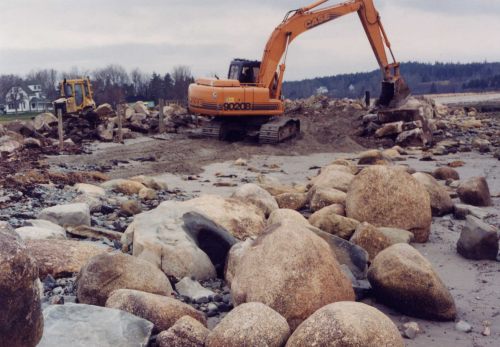
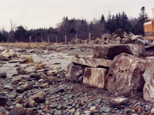
In early December, 1996, armour rock and infill were placed along the beach front
|