| Click Bike Safety again to drop this screen | ||||||||||||
| SO YOU WANT TO DO A GONZO BIKE RIDE... | ||||||||||||
| SAFETY FIRST: | ||||||||||||
Attach a bright red flashing light somewhere on the back of your bike where it is visible to drivers. It does absolutely no good hidden behind your tool kit. BTW: Turn it on !| Wear bright colours. | Ride single file. | Ride no more than 4-5 in a group. Keep a minimum 100 meters between groups to allow cars to pass. | Line ride only with people who are experienced riders. | Have a rear view mirror. Use it constantly. We are all half deaf, have wind blowing through our helmets, and today's cars are very quiet. | If you are in front, point out road hazards. If you don't know how, ask an experienced cyclist, or fall to the back. | If you are in the back, call out "Car Back" when a vehicle is approaching from the rear. Riders in front of you may not see the vehicle approaching because you're blocking the view in their mirror. | Pass other cyclists only on the left. Call out "On Your Left" as you approach from the rear in time for them to know you're coming. | When stopping at intersections or wherever, get your ass completely off the road onto the shoulder. Drivers hate us anyway, don't make it worse. | You can ride without jabbering at your fellow cyclists. Pay attention to traffic and road conditions at all times. Jabber later when stopped. It's ok while hiking, but not cycling. | Know where you're going and where you are. A cue sheet & map is sent out with every ride. Print it & bring it. If you don't know how, ask. Google Maps on your phone helps too. | Pay attention to your surroundings at all times. You are responsible for your own safety as well as that of others.
| |
| COVID PROTOCOLS: | ||||
When arriving at the ride start, park in car-clumps of 4 or 5.| Leave some room between clumps. | Keep your socializing to a minimum, and in small groups of half a dozen people. Maintain 6 feet of distance. I realize this is difficult for Gonzos, who have the same social habits as ants and Starlings. | Bring a mask in your bike bag or pocket for ice cream stops or whatever. | Do not give "concerned citizens" any reason to call the Covid Police. Appearances are more important than reality in today's world.
| |
| BASIC CYCLING INFO: |
| You should carry (at a minimum) a patch kit, tire levers, spare tube and air supply (pump or cartridge) |
| Ideally, you will know how to use the stuff listed in #1. Someone else will probably stop & help you, but by doing so they are taking time from their own ride. |
| Invest in a basic Garmin or some other form of odometer so you can follow the RWGPS cue sheets issued weekly. Or you can just follow the person in front, who may (or may not) know where they're going. |
| Be on time for ride starts. The ride leaves the start at 10AM unless posted differently. Driving in at 9:55 (or 10:05) and then getting your gear together while yakking with others is just plain rude. |
| Read the ride description & e-mail beforehand. It helps if you have an idea where you're going beforehand. Also there is often neat stuff to see or places to stop that are on the cue sheet, but not visible from the road, e.g. this week's lighthouse. Gonzo rides are not designed to be races. Enjoy the journey. |
| This year we will have two rides each week . They will both start at the same place and time, and hopefully finish at the same place and very close in time. One will be "longish" and average speed will be 20 + kph. The second will be shorter, average speed 15 + kph. |
| Your rides are mapped out & set up by two or three people who don't get paid. If you want to complain, try to keep it to constructive criticism. Suggestions for rides are always welcome, and offers to map out rides are always accepted with thanks. |
| Click Hike Distances again to drop this screen |
| Why does everyone's mapping app give different hike distances??? |
| Tracking your distance while hiking a trail involves a lot of variables and they all contribute a bit of imprecision. |
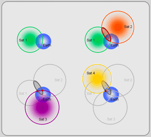
| Satellite Accuracy |
| By law, GPS satellites don't say exactly where you are. Military applications say you are here...Your Strava app...OK, here plus or minus a few meters. |
| GPS satellites triangulate your position...more satellites...better accuracy. Your tracking app logs things like position, elevation and something called DOP (Duration of Precision) to let you know how confident the GPS satellite infrastructure is in the accuracy of any one reading. |
| Location Tracking Frequency | GPS may log your position every 5 seconds, 10 seconds, 20 seconds...etc. Given the accuracy limitations...these variations will definitely affect what the app says is your hike distance. |
| Distance Calculation Algorithm | When your GPS logs 2 points (each which may be off by a few meters), how does it decide just how far you walked? All apps use a basic algorithm (the Haversine Formula - James Iman 1835) , which computes the distance between 2 points on a known sphere. That sphere is planet Earth and the generally accepted radius of the Earth is 6371 kms...again with the plus or minus. Not all apps use this exact formula or radius value. |
| Elevation Changes | Many tracking apps do not take elevation into account in their distance calculations. |
| Missed Points | For a variety of reasons, your phone app will miss a number of logging points. If you look very closely at the track your phone puts on a map or go thru the actual log...you'll see straight lines where the detail was lost for a bit. This will affect your hike distance calculation. |
| Thousands of Readings | It is very easy to generate a few thousand Longitude/Latitude readings on any one hike. With all the variations mentioned above...it is easy to see why everyone's hike distances varies, sometimes by quite a bit. You could carry 2 identical phones on a hike and the distances would be off for quite a few reasons. |
| Why do bike speedometers give slightly different distances? |
| Measuring your cycling distance with a bike speedometer has less moving parts but each has some imprecision built in. |
| Wheel Sensor |
| That little sensor on your front fork is a reed switch...basically 2 contacts that get closed by the magnet on your spoke as the wheel goes around one rotation. The sensor may not send every rotation...say a really bump road, or if using wireless, there might be a skip here and there. |
| Wheel Size Measurement |
| Speedometers ask you to input your wheel size ie: 700cc 25mm. This gives them the size of the circle and thus the radius of the wheel to cipher out just how far one rotation of that wheel will move you down the road.
You might switch to a 23mm width tire and not tell your speedometer. You may have a under-inflated tire. You may be one of those riders that wallpapers the road as you cycle hills. Any of these variables would affect the simple math that a speedometer uses. |
| Click Where Am I? again to drop this screen |
| How do I know where I am on a hike/bike? |
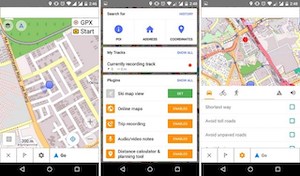
| You need an app on your phone that has maps, and you need to turn on Location on your phone (which uses the GPS chip and all those satellites in the sky). If you use Google for maps, you need data...but there is a great app out there that is free to use....OSMAND and it does not need or use data. |
| OSMAND app |
| OSM stands for Open Street Maps and is runs just like Wikipedia....crowd-sourced and lots of volunteers. You can load their free app and then load up to 8 maps for free (Nova Scotia is 1 map). | OSM has many hikes already loaded on their NS maps, including just about every Gonzo hike. So if you head out to a place like Spider Lake...you can see the myriad of trails. The app and the GPS chip on your phone will let you know where you are all the time. |
| How do I get a GPX file to follow on a hike/bike? |
| We generate our bike routes with RideWithGPS. The webpage allows you print a map of the ride, download a cue sheet and a GPX file...all for free, with no login required. The app is fussier...use the webpage. | We generate our hike routes during a hike, and then make the GPX available on the Gonzo Parking page (type Gonzo Parking into Google). | Once you have a GPX on your PC...email it to yourself as an attachment. Then get on your phone, read your mail and click on the GPX attachment. Your phone will ask you what you want to do with this file and may offer up any mapping apps as options...(Strava, Google, OSMAND). OSMAND is the free one. | If you already have some default map app for downloads....you can get the GPX into OSMAND by loading the app, going to Configure Map..Tracks...Add More...From Downloads and your GPX file will hopefully be there. |
| Click Triangulate again to drop this screen |
| Why does my phone GPS location need at least 4 satellites? |
| People have been using triangles to help measure things since back in the pyramid days. In World War II, some bright bulb figured out how to
use 3 radio receivers to triangulate the position of partisan radios.
Cell towers can do this as well, assuming the towers are essentially on the same plane (ie: 2 dimensions). |
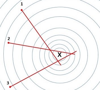 |
| In all these methods, there are built-in inconsistencies. The distance to the object in question is ciphered from the time it takes for the signal to travel from A to B. The level of accuracy depends on geometry of the devices, signal interference, atmospheric conditions and hardware/software quality .
Satellites are way out in space and definitely not on the same plane. You need that 4th satellite to compensate for the 3rd dimension. GPS satellites can generally get your location down to about 5 meters. |
 |
|
|
|
||||||
|
|
|

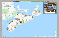
HIKING
 |
HEMLOCK RAVINE
Kent Ave off Bedford Hwy |
 |
PIGGIES MTN
571 Purcells Cove Rd, 2km past Yacht Squadron, on right |
 |
CONRADS BEACH
Conrad Rd off Lawrencetown Rd |
 |
KEARNEY LAKE #1
Hobson Trail parking, 143-155 Colins Rd off Belle St off Kearney Lake Rd |
 |
KEARNEY LAKE #2
Fox Lake Loop, 91 Saskatoon Ave, off Hamshaw Dr, off Kearney Lake Rd |
 |
BLUFF TRAIL
2890 St Margarets Bay Rd |
 |
SHUBIE PARK #1
Fairbanks Ctr, off Locks Rd, off #318 |
 |
SHUBIE PARK #2
Lake Charles north end, where #318 goes under #107 |
 |
PENNANTS POINT
Crystal Crescent Beach (2nd parking lot), off Sambro Creek Rd, off Pennant Rd |
 |
CROWBAR-MYRA
1800 Myra Rd, Porters Lake, off #7 Hwy |
 |
CROWBAR-ECHO
50 Circle Drive ballfields, off #7 Hwy, Lake Echo |
 |
JACK LAKE
87 Smith's Rd, off Hammonds Plains Rd, 3 mins from Bedford Hwy |
 |
SANDY LAKE
115 (End of) Smith's Rd, off Hammonds Plains Rd |
 |
COLPITT LAKE
Alabaster Cul-De-Sac, off Drysdale Rd, off Herring Cove |
 |
SALT MARSH
806 Bissett Rd (#322).... |
 |
HERITAGE PARK
Bissett Rd, 1200m East of Salt Marsh |
 |
LAWRENCETOWN
Lawrencetown Beach Parking Lot, off Hwy #207 |
 |
PORTERS LAKE
57 Old Harvey Lane, West Chezzetcook, off Hwy #207 |
 |
McNABS ISLAND
Fishermans Cove, off Shore Rd, off Hwy #322 |
 |
MT UNIACKE
Uniacke Estate Museum Park, just off #1 Hwy |
 |
NINE MILE RIVER
1343 Enfield Rd, off Old Enfield Rd, 8km off #2 Hwy |
 |
SUGAR MOON
221 Alex McDonald Rd off #311 Hwy |
 |
MARTINIQUE
Parking Lot #3, 193 Martinique Beach Rd, off E.Petpesquik Rd, off #7 Hwy |
 |
PROSPECT
190 Hages Ln, off Jamis Rd, off Selig Rd, off Prospect Bay Rd, off #333 |
 |
PROSPECT REVERSE
Indian Point Rd, off Prospect Bay Rd, off #333 |
 |
ADMIRAL LAKE
Parking lot just before 52 Park Road, off #357, off #7 highway |
 |
BLOMIDON PARK
3138 Pereau Rd, off #221 Hwy, off #358 Hwy |
 |
CAPE SPLIT
1029 Cape Split Rd, off #358 Hwy |
 |
TAYLORS HEAD
Point Walk, off #7 Hwy, just past Spry Harbour |
 |
SACKVILLE LAKES
440 First Lake Dr, off Cobequid Rd |
 |
BIG INDIAN
Upper parking lot, Exhibition Park, by bus stop, off #333 |
 |
SUSIES LAKE
Kents Lower Parking Lot, Off Chain Lake Drive |
 |
POLLY COVE
Between West Dover & Peggys Cove off #333 Hwy |
 |
GAFF POINT
Hirtles Beach Rd, off Kingsburg Rd, off #332 Hwy |
 |
BOTHY HIKE
Weeks Gravel Pit, off Six Mile Brook Rd, off #4, off Exit #19, #104 Hwy |
 |
MAS YOUNG BOTHY HIKE
#104...Exit #19 to #4 head East for .5km ..Turn left on Six Mile for 5.1km..Turn right on Four Mile for 2.5km..Turn left on New Road for 2.9km..Turn left on Grant Rd for 0.9km  Gordon's detailed instructions to Mas Young Gordon's detailed instructions to Mas Young
Bothy hike #35 is the same route, just this start is at Mas Young. |
 |
TELEGRAPH HILL
Parking at Powder Mill Park, off Rocky Lake Dr, #2 |
 |
LAKE WILLIAMS
Parking at Powder Mill Park, off Rocky Lake Dr, #2 |
 |
POWDER MILL
Parking just below Powder Mill Park, off Rocky Lake Dr, #2 |
 |
BLUE MOUNTAIN
Anahid Dr, off Kingswood Dr, off Larry Uteck or Hammonds Plains |
 |
WENTWORTH SKI
Ski Wentworth, 14595 Route # 4 |
 |
WENTWORTH HOSTEL
Wentworth Hostel , 249 Wentworth Station Rd, off #4 |
 |
STAGECOACH RD
Exit #7 Carpool Parking, Grant Rd, off #102 or #2 |
 |
DINGLE PARK
Sir Sandford Fleming Park, Dingle Rd, off Purcell's Cove Rd |
 |
GASPEREAU
Deep Hollow Rd (1982-1832) just after bridge, 4km off #1, Off 101 Exit #11 |
 |
TANCOOK FERRY
Chester: off Water St, off Duke St, off #3 |
 |
BLUE BEACH
Hantsport Area: off Bluff Rd, off Martin Rd, off #1 |
 |
WOLFVILLE WATERSHED
1351 Forest Hill Road, off Greenfield Rd, off Gaspereau River Rd, off #101 |
 |
POINT PLEASANT
Point Pleasant Upper Parking Lot, Off Tower Rd. |
 |
BLACK ROCK BEACH
5350 Point Pleasant Dr, Lower Parking Lot, Off Tower Rd. |
 |
MELANCHOLY MT
806 or 851 Montague Road (For GPS) |
 |
BLACK HOLE FALLS
935 Old Baxter Mill Rd, off Black Hole Rd, off #221 at Sheffield Mills |
 |
GYPSUM CAVES
Rocks Rd, off #1, off Exit4 #101 |
 |
DAWSON BROOK
Between Exit#3 & Exit4 #101. About 3m before Ellershouse overpass |
 |
DUNCANS COVE
310 Duncans Cove Rd, off Chebucto Head Rd, off #349 |
 |
OLD ANNAPOLIS
Hiking Trail Rd, Bowater/Mersey turnoff at Mill Lake, off #103 |
 |
LONG LAKE OSBORNE
154 Osborne St, between North West Arm Dr and Herring Cove Rd |
 |
LONG LAKE PROV PARK
St Margarets Bay Rd At Long Lake Park (8651) |
 |
OAKFIELD PARK
Oakfield Park Rd, chain-metal fence, 1 km off #2 Hwy |
 |
SPIDER LAKE
119 Spider Lake Rd, off Hwy #318 |
 |
LITTLE BLUFF
7475 Highway #10, New Germany, Nova Scotia |
 |
GARNET'S BLUFF
1300 Highway #208, Simpson's Corner, Nova Scotia |
 |
CAPE GEORGE
5728-5920 Sunrise Trail, Antigonish, NS |
 |
OLD COACH RD
Parking Lot, 1 km in on Old Coach Rd, off #333 (Prospect Rd) |
 |
THOMAS COVE
Parking Lot, 1 km off Economy Point Rd, 2 km off #2 (Glooscap Trail) |
 |
ECONOMY FALLS
Parking Lot, 300m off River Phillip Rd, 7 km off #2 (Glooscap Trail) |
 |
QUEENS QUARRY
#505 Purcell's Cove Rd...(Purcell's Cove Social Club) |
 |
THREE FATHOM HARBOUR
Junction of the Atlantic View Trail and the Three Fathom Harbour Road, off #207 |
 |
BRUNELLO LINKS
120 Brunello Blvd, off Timberlea Village Parkway, off St. Margarets Rd |
 |
BLUE ROCKS
Just up from the church at 135 Stonehurst Rd, intersection with S Side Rd. Off Blue Rocks Rd, off #332 in Lunenburg |
 |
NORA WARREN
Nora-Warren Trail Head. Junction of Norawarren Drive and Reginald Court off Herring Cove Road just before Paavia |
 |
BEECHVILLE
End of Dominion Cres (past ChopHouse), off Lakeside Park Dr, off Hwy #3 |
 |
GAETZ BROOK
Parking at Gaetz Brook Legion, 6644 Highway #7 in Gaetz Brook |
 |
GAETZ BROOK
Blueberry Run Trail, off Motts Dr, off E. Chezzetcook Rd |
 |
POPPY TREE 2020
Intersection of Drysdale Rd and Alabaster Way, off Herring Cove Rd |
 |
GOVERNORS LOOP
Intersection of Oceanbreeze Ave and Harnish Rd, off Herring Cove Rd (up from Pavia Coffee) |
 |
JOHNSON FALLS
End of Perrin Dr, off #118, Fall River. Also see Miller's Falls on Perrin Dr...just at Sanctuary Court |
 |
COLE HARBOUR CLIFFS
Just off the Cow Bay Rd, #322, near Rainbow Haven Beach |
 |
VICTORIA PARK
Victoria park, 29 Park Road, Truro |
 |
GULLY LAKE
1734 Kemptown Rd, Upper Kemptown, off #311 |
 |
IRISHMAN'S RD
151 Irishmans Rd, Windsor, off Wentworth Rd, off #1 |
 |
SMILEYS PARK
109 Clayton McKay Rd, Newport, off Mackay Rd, off #215 |
 |
MOSES MOUNTAIN
Mosses Mtn Road, off #14 |
 |
NICHOLS LAKE
Sunrise Interfaith Cemetery, 2025 Prospect Rd, Hatchet Lake |
 |
6 MILE LAKE
End of Dominion Cres, off Beechville Park Dr, off St. Margarets Bay Rd |
 |
CASTLE ROCK
East River Trail Parking, off #329, just off #3 |
 |
STORY HEAD
Bottom of East Chezzetcook Rd. Turn right before it becomes Long Beach Rd |
 |
MCDONALD SPORTS PARK
280 Champions Way, off Cobequid Rd, off #2 |
 |
YORK REDOUBT
31 Fire Rd, Herring Cove (#253) |
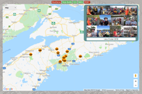
BIKING
MISCELLANEOUS
TRAIL MAPS
DIPPER MAPS
MISC MAPS
CARPOOLS
MISC HIKES
MISC BIKE RIDES
PADDLING
|
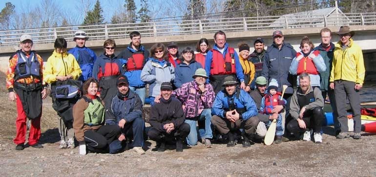
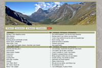
GONZO BIKING SAFETY
Biking Safety suggestions for our day Bikes Biking Safety
|
|
LUNENBURG
Curling Club, off 87 Victoria Rd |
|
SOUTH MAITLAND
Station Rd parking lot, off Hwy #215, South Maitland |
|
MAITLAND
Freize & Roy, off Hwy #215, Maitland |
|
KENNETCOOK
Snappers Bar parking lot, intersection of #354 & #236 |
|
ASPOTOGAN
9 Firehall Rd, Blandford, off #329, off #3 |
|
ASPOTOGAN CARPOOL
Exit 6 carpool parking lot |
|
WOLFVILLE
282 Main St, across from Willow Park, off #1. |
|
MAHONE BAY
3 Churches parking lot, 18 Edgewater St, Mahone Bay, off #3 |
|
PORT WILLIAMS PUB
Port Pub parking, off Kars St, off #358 |
|
PORT WILLIAMS CHURCH
1031 Main St, Port Williams... #358 |
|
PORT WILLIAMS SCHOOL
Port Williams School, 1261 Belcher St. Turn left on Belcher as you come into Port Williams. |
|
ENFIELD - Grant Rd
Exit #7 Carpool Parking, 11-23 Grant Rd, Enfield, off #2 |
|
WEST CHEZZ
7020 Marine Dr, off #207, just up from Acadian Tea Room |
|
PORTERS LAKE
5240 Nova Scotia Trunk 7, Porters Lake |
|
STEWIACKE
Whistlers Pub, 50 Main St East, Exit 11 off #102 |
|
MASTODON RIDGE
87 Main St W, Stewiacke, Exit 11 off #102 |
|
KENTVILLE
Kentville Court House, 87 Cornwallis St, off #341, off #1 |
|
KENTVILLE burbs
Gary Pearl Drive, off Highway #1, between Kentville and Coldbrook |
|
WINDSOR
17 Water St, Windsor. Tim Hortons off Exit #6 |
|
MONUMENT LOOP ROAD
24-28 Monument Loop, Head of Jeddore, off Hwy #7 |
|
TATA REC CENTER
North Shore Rec Center, 30 Blair Ave, Tatamagouche |
|
SHUBENACADIE
Heritage Baptist Church, downtown Shubenacadie |
|
SHUBENACADIE
Milford Station Carpool, Hwy #14, just off #2 |
|
HANTSPORT
Baptist Church, 1 Main St, downtown Hantsport |
|
BROOKLYN
Newport United Church parking lot, Hwy #14 & #215, Brooklyn |
|
BROOKLYN ARENA
Brookyn Arena, Hwy #14 & #215, Brooklyn, Brooklyn |
|
GRAHAMS GROVE
45 Grahams Grove, Hwy #7 & Prince Albert Rd, Dartmouth |
|
LONDONDERRY
Side road, off #4 (heading North), off Exit #11 off #104 |
|
MUSQUODOBOIT TRAIL
Parking lot just before 52 Park Road, off #357, off #7 highway |
|
MUSQUODOBOIT ROAD
Parking lot by old Rail Station, across from Dobbit's on #7 highway |
|
MUSQUODOBOIT RINK
Rink parking lot, 67 Park Road, off #357, off #7 highway |
|
MUSQUODOBOIT SCHOOL
Eastern Shore District High School, 35 West Petpeswick Rd., Musquodoboit Harbour, off #7 highway |
|
BIKE&BEAN
5401 St Margarets Bay Rd, Upper Tantallon |
|
BERWICK
Western Kings Health Ctr, 121 Orchard St, off Commercial, Berwick. Drive around behind the building. |
|
NEW GLASGOW
Parking lot behind Pictou Co. Wellness Center, off MacGregor Ave, off #4, off #104 Exit #23. |
|
ONSLOW
61 Onslow Rd. Turn left at the stop sign on the exit ramp and go about 500 meters, the Colchester Jr. High school is on your right. Park in the upper lot. |
|
WENTWORTH CHURCH
Wentworth United Church, 13315 Highway #4, just past Wentworth Market. |
|
WENTWORTH PARK
Wentworth Provincial Park, just before Highway #246. |
|
WENTWORTH REC CENTER
Wentworth Recreation Center, just after Highway #246. |
|
GREAT VILLAGE
Great Village Elementary School, Highway #2. |
|
SHEARWATER FLYER
81 Hines Rd where it crosses Rail/Trail or head to CanEx parking lot |
|
ASPOTOGAN TRAIL
Aspotogan Trail entrance in Hubbards, 400m past the Trellis Cafe |
|
ASHBURN
Chain Lakes Trail crossing at 3250 Joseph Howe Dr. Entrance to Ashburn Golf Club |
|
COW BAY
#15 Bissett Road, United Church, off Cole Harbour Road *** Ignore the Trail start and go to the Church |
|
SAMBRO
Frog Pond Park by 232 Purcells Cove Rd. |
|
AYLESFORD
United Church, Aylesford. Take Exit #15 off 101. Intersection #1 and New Rd. |
|
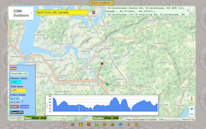
ST. CROIX
Just off Hwy #101 Exit #4. Intersection with #1 |
|
THE LOOKOFF
The Lookoff. 14km north of Port Williams on #358 |
|
MILL VILLAGE
Car Pool Parking Lot, off Port Medway Rd, off Old Highway#3, off #103...Exit #17 |
|
UPPER KENNETCOOK
Northfield Christian Fellowship Church, 437 Ranch Rd, off Northfield Rd, off #236 |
|
GAETZ BROOK
Blueberry Run Trail, off Motts Dr, off E. Chezzetcook Rd |
|
NSCC CAMPUS
NSCC Campus Truro, off Arthur St, off #2 |
|
HEAD OF JEDDORE
Sobeys parking lot, Jeddore #8990 on #7 |
|
PUGWASH
Cyrus Eaton Memorial School, 171 Queen St. Pugwash |
|
GIBRALTAR ROCK
Gibraltar Rock Loop Trailhead, off #357, Musquodoboit |
|
NORTHPORT
31 Rivers Wood Loop, off #366, Northport |
|
BRIDGEWATER
421 LaHave Street (#3), by the Value Village, Bridgewater |
|
QUEENSLAND BEACH
Conrads Rd, Hubbards |
|
CHESTER
Chester Family Resource, 188 Pig Loop Rd, Chester |
|
MOUNT UNIACKE
Evangeline Trail Parking Lot, across from the Irving, Exit #3 off #101 |
|
GRAND PRE
Parking lot of the National Historic site Grand-Pre, #1, Exit #10 off #101 |
|
ELDERBANK
Parking lot Elderbank Park, #357 just after #212 out of Halifax |
|
VICTORIA PARK
Victoria Park, 29 Park Road, Truro |
MISCELLANEOUS
| |
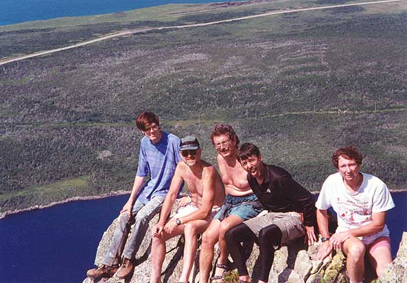
| GONZO TRIBUTES
Ross, Chris & Keith | |
| |
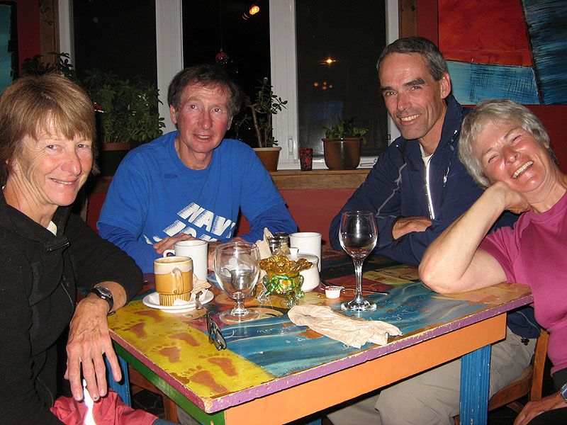
| GONZO ARCHIVES
Remembering is 1/2 the fun, especially when you forgot already. | |
| |
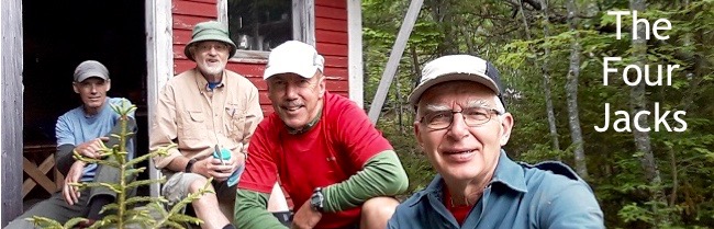
| THREE MILE
Follow the Four Jacks as they fixup up JackKnife's retirement home. | |
TRAIL MAPS
 Nova Scotia TRAILS Nova Scotia TRAILS
| TRAILPEAK
| Nova Scotia WATERFALLS
| NS HIDDEN WONDERS
| ALLTRAILS
| HIKE Nova Scotia
| Colchester Trails
| TrailForks
| WikiLoc
|
DIPPER MAPS
| |
| GPX VIEWER/OPTIMIZER
Browse your GPX files. Play with the Optimizer if you like to cut down file sizes. | |
| |
| GPX CREATE
Make up bike or hikes routes. Check distances and elevations. | |
| |
| GONZO SCOUT HIKES
Browse the Gonzo scouting hikes all around HRM and now beyond. | |
| |
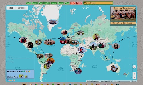
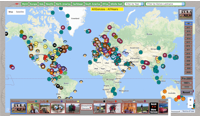
| GONZO TRAVEL MAPS
Follow Gonzos travelling about the planet. We are a busy crowd. | |
| |
| NS Brewery Map
Interactive map for NS Breweries. | |

| |
| PASSWORD STRENGTH
Test password strength. Learn to generate multiple secure passwords. | |
| |
| PACK LIST GENERATOR
Generate packlists for hiking, biking, camping, overseas, etc. | |
| |
| LEVY CRUISER 2018
Bernie & Wendy Levy paddle EVERY month of the year, 12 years running. | |
| |
| Sue's UNESCO Sites
Sue Green has made a point of visiting over 100 UNESCO sites in her world travels. | |
MISC MAPS
| |
| OSMAND Offline Maps
This app works offline, has free maps and almost all our hiking trails. | |

| |
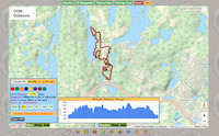
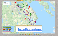
| RideWithGPS
No login required to Print Maps & Cue Sheets & Export GPX files. All of our rides and most hikes have a route map link. | |
| |
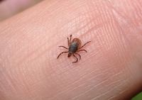
| IT'S TICK SEASON!!!
Donna Lugar's Tick Presentation (Powerpoint download). | |
| GONZO STATS
An ongoing collection of Gonzo running/sports statistics. |
| GONZO PACKING LISTS
Packing List suggestions for our day Hikes and Bikes. |
CARPOOLS
|
COBEQUID RD TIMMIES
257 Cobequid Rd, Lower Sackville, NS, Canada |
|
SACKVILLE TERMINAL
7 Walker Ave, Lower Sackville, NS, Canada |
|
FOREST HILLS, #7 SOBEYS
7-612 Main St, Dartmouth, NS, Canada |
|
FALL RIVER, #2 TIMMIES
3290 Lake Thomas Dr, Fall River, NS, Canada |
|
HAMMONDS PLNS, #103 TIMMIES
3614 Hammonds Plains Rd, Upper Tantallon, NS |
|
OSBORNE ST, NW ARM TIMMIES
154 Osborne St, Halifax, NS, Canada |
MISC HIKES
MISC BIKE RIDES
PADDLING
|
BEDFORD BASIN
Lion's Pool in Bedford, Shipyard Rd, off Shore Dr |